Villanova geodata
Villanova (Emilia-Romagna) is a populated place; located in Italy in Europe/Rome (GMT+2) time zone. With population of 777 people, there are 7779 cities with bigger population in this country. Compared to other cities in Italy, 52.3% of cities are located further ↑North; 55.6% of cities are located further ←West and 87.4% of cities have higher elevation than Villanova. Note1
Administrative division(s):
- Level 1: Emilia-Romagna
- Level 2: Provincia di Forlì-Cesena
- Level 3: Forlì


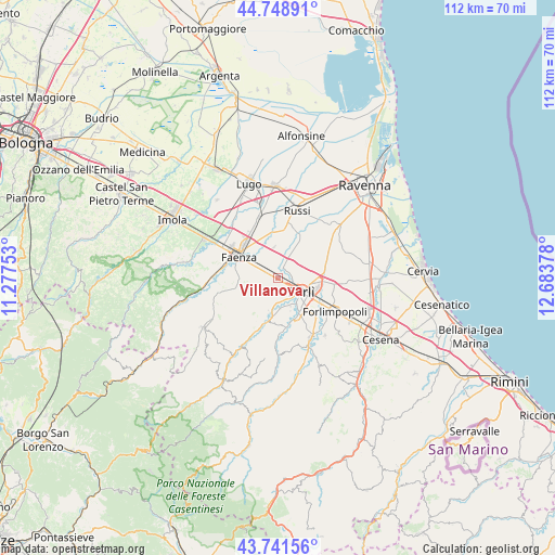
Villanova GPS coordinates[2]
44° 14' 50.604" North, 11° 58' 50.34" East
| Map corner | latitude | longitude |
|---|---|---|
| Upper-left | 44.74891°, | 11.27753° |
| Center: | 44.24739°, | 11.98065° |
| Lower-right: | 43.74156°, | 12.68378° |
| Map W x H: | 112×112 km | = 69.6×69.6mi |
| max Lat: | 47.04031° ⇑52.3% North |
| Villanova: | 44.24739° |
| min Lat: | ⇓47.7% South 35.50142° |
| min Long | Villanova | max Long |
| 6.69888° | 11.98065° | 18.48682° |
| W 55.6%⇐ | ⇒44.4% E |
Elevation
Elevation of Villanova is 24 m = 79 ft, and this is 282.7 m = 927 ft below average elevation for this country.
| Max E: |
2085 m = 6841 ft | 87.4% |
| Avg. | 306.7 m = 1006 ft | |
| Villanova | 24 m = 79 ft | |
Min E: |
-4 m = -13 ft | 12.6% |
See also: Italy elevation on elevation.city.
Geographical zone
Villanova is located in North temperate zone (between Tropic of Cancer and the Arctic Circle). Distance of this Northern Tropic circle is 2313.9 km =1437.8 mi to South.| Distance of | km | miles | from Villanova |
|---|---|---|---|
| North Pole | 5087.2 | 3161 | to North |
| Arctic Circle | 2481.3 | 1541.8 | to North |
| Tropic Cancer | 2313.9 | 1437.8 | to South |
| Equator | 4919.8 | 3057 | to South |


Nearby cities:
15 places around Villanova: (largest is in red/bold)
• Carpena
9.6 km =6 mi,  135°
135°
• Carpinello
11 km =6.8 mi,  94°
94°
• Castrocaro Terme
8.4 km =5.2 mi,  197°
197°
• Castrocaro Terme e Terra del Sole
6.9 km =4.3 mi,  193°
193°
• Faenza
9.3 km =5.8 mi,  300°
300°
• Fiumana
11.6 km =7.2 mi,  177°
177°
• Forlimpopoli
13.4 km =8.3 mi,  117°
117°
• Forlì
5.6 km =3.5 mi, 120°
• Granarolo
12.9 km =8 mi,  343°
343°
• Reda
6.1 km =3.8 mi,  350°
350°
• Roncadello
5.6 km =3.5 mi,  67°
67°
• San Lorenzo in Noceto
9.8 km =6.1 mi,  167°
167°
• San Pietro In Vincoli
14.4 km =8.9 mi, 65°
• San Pietro in Trento
11.2 km =7 mi,  46°
46°
• Selbagnone
13.1 km =8.1 mi,  128°
128°
Sources, notices
• [Note1] Compared only with cities in Italy existing in our database
• [Src1] Map data: © OpenStreetMap contributors (CC-BY-SA)
• [Src2] Other city data from geonames.org with taken over terms of usage.
• [Src3] Geographical zone / Annual Mean Temperature by Robert A. Rohde @ Wikipedia
