Castrocaro Terme e Terra del Sole geodata
Castrocaro Terme e Terra del Sole (Emilia-Romagna) is a seat of a third-order administrative division; located in Italy in Europe/Rome (GMT+2) time zone. With population of 5,555 people, there are 1766 cities with bigger population in this country. Compared to other cities in Italy, 52.9% of cities are located further ↑North; 55.4% of cities are located further ←West and 77.7% of cities have higher elevation than Castrocaro Terme e Terra del Sole. Note1
Administrative division(s):
- Level 1: Emilia-Romagna
- Level 2: Provincia di Forlì-Cesena
- Level 3: Castrocaro Terme e Terra del Sole
Current local time in Castrocaro Terme e Terra del Sole:
07:01 PM, WednesdayDifference from your time zone: hours


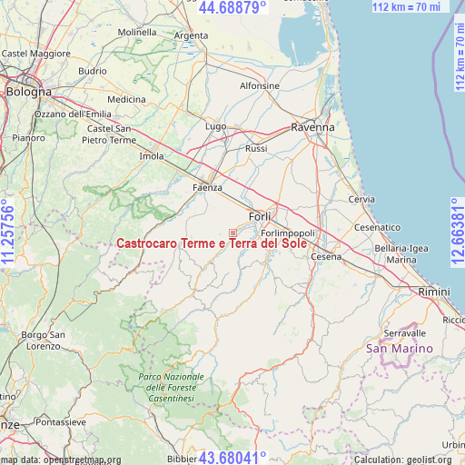
Castrocaro Terme e Terra del Sole GPS coordinates[2]
44° 11' 12.336" North, 11° 57' 38.448" East
| Map corner | latitude | longitude |
|---|---|---|
| Upper-left | 44.68879°, | 11.25756° |
| Center: | 44.18676°, | 11.96068° |
| Lower-right: | 43.68041°, | 12.66381° |
| Map W x H: | 112.1×112.1 km | = 69.7×69.7mi |
| max Lat: | 47.04031° ⇑52.9% North |
| Castrocaro Terme e Terra del Sole: | 44.18676° |
| min Lat: | ⇓47.1% South 35.50142° |
| min Long | Castrocaro Term | max Long |
| 6.69888° | 11.96068° | 18.48682° |
| W 55.4%⇐ | ⇒44.6% E |
Elevation
Elevation of Castrocaro Terme e Terra del Sole is 61 m = 200 ft, and this is 245.7 m = 806 ft below average elevation for this country.
| Max E: |
2085 m = 6841 ft | 77.7% |
| Avg. | 306.7 m = 1006 ft | |
| Castrocaro Terme e Terra del Sole | 61 m = 200 ft | |
Min E: |
-4 m = -13 ft | 22.3% |
See also: Italy elevation on elevation.city.
Geographical zone
Castrocaro Terme e Terra del Sole is located in North temperate zone (between Tropic of Cancer and the Arctic Circle). Distance of this Northern Tropic circle is 2307.2 km =1433.6 mi to South.| Distance of | km | miles | from Castrocaro Terme e Terra del Sole |
|---|---|---|---|
| North Pole | 5094 | 3165.3 | to North |
| Arctic Circle | 2488.1 | 1546 | to North |
| Tropic Cancer | 2307.2 | 1433.6 | to South |
| Equator | 4913.1 | 3052.9 | to South |


Nearby cities:
15 places around Castrocaro Terme e Terra del Sole: (largest is in red/bold)
• Carpena
8.3 km =5.2 mi,  91°
91°
• Castrocaro Terme
1.5 km =0.9 mi,  215°
215°
• Dovadola
9.3 km =5.8 mi, 219°
• Faenza
13.2 km =8.2 mi,  330°
330°
• Fiumana
5.3 km =3.3 mi,  156°
156°
• Forlì
7.5 km =4.7 mi,  58°
58°
• Fratta Terme
12.4 km =7.7 mi,  114°
114°
• Meldola
10.4 km =6.5 mi,  128°
128°
• Predappio
9.5 km =5.9 mi,  168°
168°
• Reda
12.8 km =8 mi,  2°
2°
• Roncadello
11.2 km =7 mi,  37°
37°
• San Colombano
12.1 km =7.5 mi,  144°
144°
• San Lorenzo in Noceto
4.6 km =2.9 mi, 127°
• Selbagnone
11.9 km =7.4 mi,  96°
96°
• Villanova
6.9 km =4.3 mi,  13°
13°
Sources, notices
• [Note1] Compared only with cities in Italy existing in our database
• [Src1] Map data: © OpenStreetMap contributors (CC-BY-SA)
• [Src2] Other city data from geonames.org with taken over terms of usage.
• [Src3] Geographical zone / Annual Mean Temperature by Robert A. Rohde @ Wikipedia
