Casette geodata
Casette (Friuli Venezia Giulia) is a populated place; located in Italy in Europe/Rome (GMT+2) time zone. With population of 603 people, there are 8976 cities with bigger population in this country. Compared to other cities in Italy, 87.7% of cities are located further ↓South; 67% of cities are located further ←West and 92.1% of cities have higher elevation than Casette. Note1
Administrative division(s):
- Level 1: Friuli Venezia Giulia
- Level 2: Provincia di Pordenone
- Level 3: Sesto al Reghena


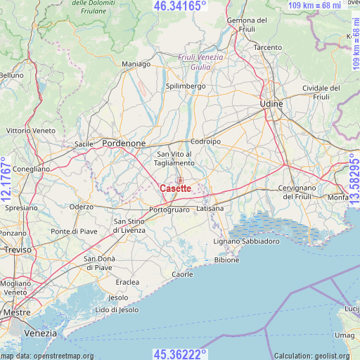
Casette GPS coordinates[2]
45° 51' 14.724" North, 12° 52' 47.352" East
| Map corner | latitude | longitude |
|---|---|---|
| Upper-left | 46.34165°, | 12.1767° |
| Center: | 45.85409°, | 12.87982° |
| Lower-right: | 45.36222°, | 13.58295° |
| Map W x H: | 108.9×108.9 km | = 67.7×67.7mi |
| max Lat: | 47.04031° ⇑12.3% North |
| Casette: | 45.85409° |
| min Lat: | ⇓87.7% South 35.50142° |
| min Long | Casette | max Long |
| 6.69888° | 12.87982° | 18.48682° |
| W 67%⇐ | ⇒33% E |
Elevation
Elevation of Casette is 14 m = 46 ft, and this is 292.7 m = 960 ft below average elevation for this country.
| Max E: |
2085 m = 6841 ft | 92.1% |
| Avg. | 306.7 m = 1006 ft | |
| Casette | 14 m = 46 ft | |
Min E: |
-4 m = -13 ft | 7.9% |
See also: Italy elevation on elevation.city.
Geographical zone
Casette is located in North temperate zone (between Tropic of Cancer and the Arctic Circle). Distance of this North polar circle is 2302.7 km =1430.8 mi to North.| Distance of | km | miles | from Casette |
|---|---|---|---|
| North Pole | 4908.6 | 3050.1 | to North |
| Arctic Circle | 2302.7 | 1430.8 | to North |
| Tropic Cancer | 2492.6 | 1548.8 | to South |
| Equator | 5098.5 | 3168.1 | to South |


Nearby cities:
15 places around Casette: (largest is in red/bold)
• Bagnarola
2.2 km =1.4 mi,  311°
311°
• Cintello
4.2 km =2.6 mi,  197°
197°
• Cinto Caomaggiore
8.2 km =5.1 mi,  248°
248°
• Cordovado
1.2 km =0.7 mi,  158°
158°
• Fossalta di Portogruaro
7.2 km =4.5 mi, 160°
• Giai
6.4 km =4 mi,  226°
226°
• Gleris
4.7 km =2.9 mi,  355°
355°
• Gruaro
3.7 km =2.3 mi, 234°
• Gruaro-Bagnara
2.6 km =1.6 mi,  238°
238°
• Morsano
3.8 km =2.4 mi,  80°
80°
• Ramuscello
3 km =1.9 mi,  7°
7°
• San Vito al Tagliamento
7.1 km =4.4 mi,  347°
347°
• Savorgnano
5.1 km =3.2 mi,  336°
336°
• Sesto al Reghena
5.2 km =3.2 mi,  264°
264°
• Teglio Veneto
4.2 km =2.6 mi,  175°
175°
Sources, notices
• [Note1] Compared only with cities in Italy existing in our database
• [Src1] Map data: © OpenStreetMap contributors (CC-BY-SA)
• [Src2] Other city data from geonames.org with taken over terms of usage.
• [Src3] Geographical zone / Annual Mean Temperature by Robert A. Rohde @ Wikipedia
