Trebaseleghe geodata
Trebaseleghe (Veneto) is a seat of a third-order administrative division; located in Italy in Europe/Rome (GMT+2) time zone. With population of 7,901 people, there are 1234 cities with bigger population in this country. Compared to other cities in Italy, 76.7% of cities are located further ↓South; 56.5% of cities are located further ←West and 89% of cities have higher elevation than Trebaseleghe. Note1


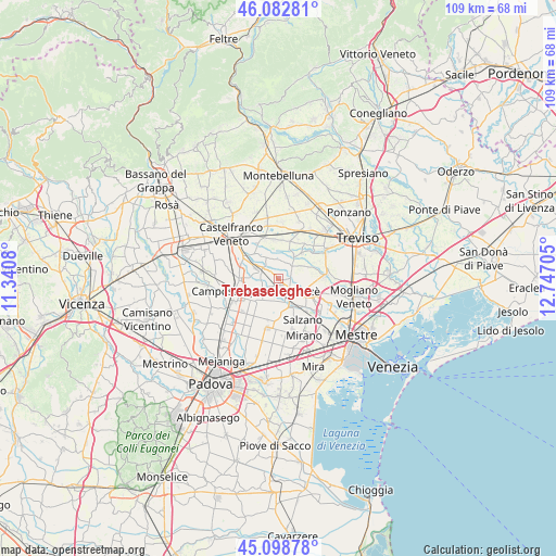
Trebaseleghe GPS coordinates[2]
45° 35' 34.62" North, 12° 2' 38.112" East
| Map corner | latitude | longitude |
|---|---|---|
| Upper-left | 46.08281°, | 11.3408° |
| Center: | 45.59295°, | 12.04392° |
| Lower-right: | 45.09878°, | 12.74705° |
| Map W x H: | 109.4×109.4 km | = 68×68mi |
| max Lat: | 47.04031° ⇑23.3% North |
| Trebaseleghe: | 45.59295° |
| min Lat: | ⇓76.7% South 35.50142° |
| min Long | Trebaseleghe | max Long |
| 6.69888° | 12.04392° | 18.48682° |
| W 56.5%⇐ | ⇒43.5% E |
Elevation
Elevation of Trebaseleghe is 20 m = 66 ft, and this is 286.7 m = 941 ft below average elevation for this country.
| Max E: |
2085 m = 6841 ft | 89% |
| Avg. | 306.7 m = 1006 ft | |
| Trebaseleghe | 20 m = 66 ft | |
Min E: |
-4 m = -13 ft | 11% |
See also: Italy elevation on elevation.city.
Geographical zone
Trebaseleghe is located in North temperate zone (between Tropic of Cancer and the Arctic Circle). Distance of this North polar circle is 2331.7 km =1448.9 mi to North.| Distance of | km | miles | from Trebaseleghe |
|---|---|---|---|
| North Pole | 4937.6 | 3068.1 | to North |
| Arctic Circle | 2331.7 | 1448.9 | to North |
| Tropic Cancer | 2463.5 | 1530.7 | to South |
| Equator | 5069.5 | 3150 | to South |


Nearby cities:
15 places around Trebaseleghe: (largest is in red/bold)
• Badoere
5.6 km =3.5 mi,  34°
34°
• Cappelletta
2.9 km =1.8 mi,  151°
151°
• Fossalta
3.7 km =2.3 mi,  238°
238°
• Levada
3.6 km =2.2 mi,  16°
16°
• Massanzago-Ca' Baglioni-San Dono
5 km =3.1 mi,  214°
214°
• Moniego
4.9 km =3 mi,  136°
136°
• Noale
5.5 km =3.4 mi,  162°
162°
• Piombino Dese
4.3 km =2.7 mi,  295°
295°
• Rio San Martino
5.3 km =3.3 mi,  90°
90°
• Ronchi
3.4 km =2.1 mi,  272°
272°
• Rustega
5.9 km =3.7 mi, 243°
• Sant'Ambrogio
3.1 km =1.9 mi,  61°
61°
• Scandolara
5 km =3.1 mi, 60°
• Scorzè
5.7 km =3.5 mi,  111°
111°
• Torreselle
4.5 km =2.8 mi,  338°
338°
Sources, notices
• [Note1] Compared only with cities in Italy existing in our database
• [Src1] Map data: © OpenStreetMap contributors (CC-BY-SA)
• [Src2] Other city data from geonames.org with taken over terms of usage.
• [Src3] Geographical zone / Annual Mean Temperature by Robert A. Rohde @ Wikipedia
