Igne geodata
Igne (Veneto) is a populated place; located in Italy in Europe/Rome (GMT+2) time zone. With population of 527 people, there are 9666 cities with bigger population in this country. Compared to other cities in Italy, 96.5% of cities are located further ↓South; 59.5% of cities are located further ←West and 85.2% of cities have lower elevation than Igne. Note1


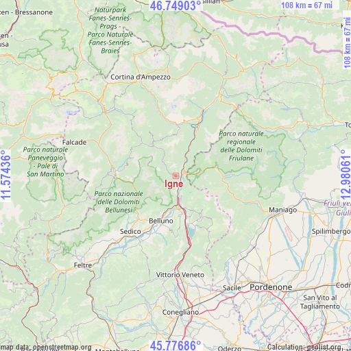
Igne GPS coordinates[2]
46° 15' 54.36" North, 12° 16' 38.928" East
| Map corner | latitude | longitude |
|---|---|---|
| Upper-left | 46.74903°, | 11.57436° |
| Center: | 46.2651°, | 12.27748° |
| Lower-right: | 45.77686°, | 12.98061° |
| Map W x H: | 108.1×108.1 km | = 67.2×67.2mi |
| max Lat: | 47.04031° ⇑3.5% North |
| Igne: | 46.2651° |
| min Lat: | ⇓96.5% South 35.50142° |
| min Long | Igne | max Long |
| 6.69888° | 12.27748° | 18.48682° |
| W 59.5%⇐ | ⇒40.5% E |
Elevation
Elevation of Igne is 617 m = 2024 ft, and this is 310.3 m = 1018 ft above average elevation for this country.
| Max E: |
2085 m = 6841 ft | 14.8% |
| Igne | 617 m 2024 ft | |
| Avg. | 306.7 m = 1006 ft | |
Min E: |
-4 m = -13 ft | 85.2% |
See also: Italy elevation on elevation.city.
Geographical zone
Igne is located in North temperate zone (between Tropic of Cancer and the Arctic Circle). Distance of this North polar circle is 2257 km =1402.4 mi to North.| Distance of | km | miles | from Igne |
|---|---|---|---|
| North Pole | 4862.9 | 3021.7 | to North |
| Arctic Circle | 2257 | 1402.4 | to North |
| Tropic Cancer | 2538.3 | 1577.2 | to South |
| Equator | 5144.2 | 3196.5 | to South |


Nearby cities:
15 places around Igne: (largest is in red/bold)
• Castello Lavazzo
3.1 km =1.9 mi,  45°
45°
• Cimolais
12.6 km =7.8 mi,  77°
77°
• Codissago
2.8 km =1.7 mi,  64°
64°
• Erto
7.3 km =4.5 mi, 80°
• Forno di Zoldo
12.1 km =7.5 mi,  321°
321°
• Fortogna
4 km =2.5 mi,  166°
166°
• Lamosano
13.3 km =8.3 mi,  140°
140°
• Levego
12.1 km =7.5 mi,  184°
184°
• Longarone
1.7 km =1.1 mi,  87°
87°
• Ospitale di Cadore
7.8 km =4.8 mi,  26°
26°
• Pieve d'Alpago
12.4 km =7.7 mi,  151°
151°
• Ponte nelle Alpi
9.4 km =5.8 mi, 177°
• Ponte nelle Alpi-Polpet
8.5 km =5.3 mi, 179°
• Soccher-Paiane-Casan-Arsie
9.7 km =6 mi,  164°
164°
• Soverzene
7.1 km =4.4 mi, 164°
Sources, notices
• [Note1] Compared only with cities in Italy existing in our database
• [Src1] Map data: © OpenStreetMap contributors (CC-BY-SA)
• [Src2] Other city data from geonames.org with taken over terms of usage.
• [Src3] Geographical zone / Annual Mean Temperature by Robert A. Rohde @ Wikipedia
