Verbania geodata
Verbania (Piedmont) is a seat of a second-order administrative division; located in Italy in Europe/Rome (GMT+2) time zone. With population of 31,070 people, there are 259 cities with bigger population in this country. Compared to other cities in Italy, 89.9% of cities are located further ↓South; 87.3% of cities are located further →East and 54.6% of cities have higher elevation than Verbania. Note1
Administrative division(s):
- Level 1: Piedmont
- Level 2: Provincia Verbano-Cusio-Ossola
- Level 3: Verbania


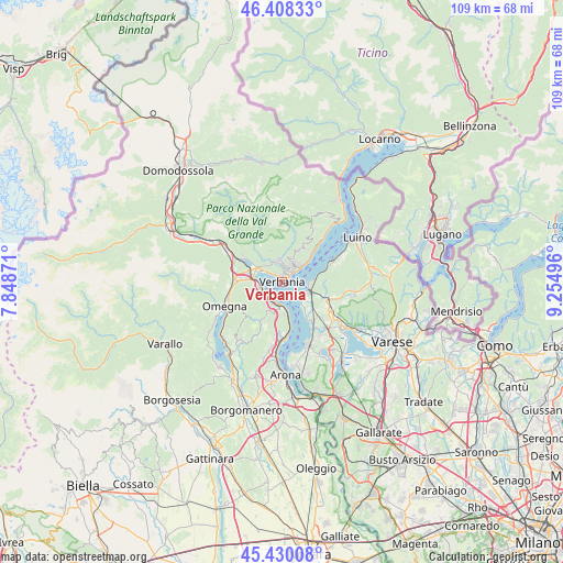
Verbania GPS coordinates[2]
45° 55' 16.896" North, 8° 33' 6.588" East
| Map corner | latitude | longitude |
|---|---|---|
| Upper-left | 46.40833°, | 7.84871° |
| Center: | 45.92136°, | 8.55183° |
| Lower-right: | 45.43008°, | 9.25496° |
| Map W x H: | 108.8×108.8 km | = 67.6×67.6mi |
| max Lat: | 47.04031° ⇑10.1% North |
| Verbania: | 45.92136° |
| min Lat: | ⇓89.9% South 35.50142° |
| min Long | Verbania | max Long |
| 6.69888° | 8.55183° | 18.48682° |
| W 12.7%⇐ | ⇒87.3% E |
Elevation
Elevation of Verbania is 205 m = 673 ft, and this is 101.7 m = 334 ft below average elevation for this country.
| Max E: |
2085 m = 6841 ft | 54.6% |
| Avg. | 306.7 m = 1006 ft | |
| Verbania | 205 m = 673 ft | |
Min E: |
-4 m = -13 ft | 45.4% |
See also: Italy elevation on elevation.city.
Geographical zone
Verbania is located in North temperate zone (between Tropic of Cancer and the Arctic Circle). Distance of this North polar circle is 2295.2 km =1426.2 mi to North.| Distance of | km | miles | from Verbania |
|---|---|---|---|
| North Pole | 4901.1 | 3045.4 | to North |
| Arctic Circle | 2295.2 | 1426.2 | to North |
| Tropic Cancer | 2500.1 | 1553.5 | to South |
| Equator | 5106 | 3172.7 | to South |


Nearby cities:
15 places around Verbania: (largest is in red/bold)
• Arizzano
4.7 km =2.9 mi,  30°
30°
• Baveno
4.2 km =2.6 mi,  249°
249°
• Bee
5 km =3.1 mi,  21°
21°
• Bieno
4.5 km =2.8 mi,  317°
317°
• Cambiasca
4.6 km =2.9 mi,  353°
353°
• Cossogno
5.8 km =3.6 mi,  325°
325°
• Feriolo
5.7 km =3.5 mi,  280°
280°
• Fondotoce
5.4 km =3.4 mi,  301°
301°
• Ghiffa
5.4 km =3.4 mi,  49°
49°
• Laveno
5.5 km =3.4 mi,  104°
104°
• Pallanza-Intra-Suna
2.3 km =1.4 mi,  38°
38°
• San Bernardino Verbano
4.6 km =2.9 mi, 327°
• Santino
4.6 km =2.9 mi, 326°
• Stresa
4.5 km =2.8 mi,  193°
193°
• Vignone
4.5 km =2.8 mi,  11°
11°
Sources, notices
• [Note1] Compared only with cities in Italy existing in our database
• [Src1] Map data: © OpenStreetMap contributors (CC-BY-SA)
• [Src2] Other city data from geonames.org with taken over terms of usage.
• [Src3] Geographical zone / Annual Mean Temperature by Robert A. Rohde @ Wikipedia
