Molino Vecchio-Scapitola-Baio geodata
Molino Vecchio-Scapitola-Baio (Liguria) is a seat of a third-order administrative division; located in Italy in Europe/Rome (GMT+2) time zone. With population of 61 people, there are 11568 cities with bigger population in this country. Compared to other cities in Italy, 51.8% of cities are located further ↓South; 80.2% of cities are located further →East and 82.5% of cities have lower elevation than Molino Vecchio-Scapitola-Baio. Note1
Current local time in Molino Vecchio-Scapitola-Baio:
06:55 PM, WednesdayDifference from your time zone: hours


Molino Vecchio-Scapitola-Baio GPS coordinates[2]
44° 33' 19.98" North, 9° 4' 5.376" East
| Map corner | latitude | longitude |
|---|---|---|
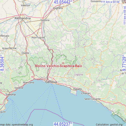
| Upper-left | 45.05442°, | 8.36504° |
| Center: | 44.55555°, | 9.06816° |
| Lower-right: | 44.05237°, | 9.77129° |
| Map W x H: | 111.4×111.4 km | = 69.2×69.2mi |
| max Lat: | 47.04031° ⇑48.2% North |
| Molino Vecchio-Scapitola-Baio: | 44.55555° |
| min Lat: | ⇓51.8% South 35.50142° |
| min Long | Molino Vecchio- | max Long |
| 6.69888° | 9.06816° | 18.48682° |
| W 19.8%⇐ | ⇒80.2% E |
Elevation
Elevation of Molino Vecchio-Scapitola-Baio is 563 m = 1847 ft, and this is 256.3 m = 841 ft above average elevation for this country.
| Max E: |
2085 m = 6841 ft | 17.5% |
| Molino Vecchio-Scapitola-Baio | 563 m 1847 ft | |
| Avg. | 306.7 m = 1006 ft | |
Min E: |
-4 m = -13 ft | 82.5% |
See also: Italy elevation on elevation.city.
Geographical zone
Molino Vecchio-Scapitola-Baio is located in North temperate zone (between Tropic of Cancer and the Arctic Circle). Distance of this Northern Tropic circle is 2348.2 km =1459.1 mi to South.| Distance of | km | miles | from Molino Vecchio-Scapitola-Baio |
|---|---|---|---|
| North Pole | 5052.9 | 3139.7 | to North |
| Arctic Circle | 2447.1 | 1520.6 | to North |
| Tropic Cancer | 2348.2 | 1459.1 | to South |
| Equator | 4954.1 | 3078.3 | to South |


Nearby cities:
15 places around Molino Vecchio-Scapitola-Baio: (largest is in red/bold)
• Borgo Fornari-Pieve
11.1 km =6.9 mi,  289°
289°
• Busalla
9.9 km =6.2 mi,  279°
279°
• Carrega Ligure
11 km =6.8 mi,  50°
50°
• Casella
5.8 km =3.6 mi,  247°
247°
• Crocefieschi
4.5 km =2.8 mi,  308°
308°
• Davagna
10.1 km =6.3 mi,  171°
171°
• Isorelle
8.5 km =5.3 mi, 278°
• Mongiardino Ligure
8.8 km =5.5 mi,  358°
358°
• Montoggio
4.5 km =2.8 mi,  199°
199°
• Piccarello
11.4 km =7.1 mi,  225°
225°
• Propata
9.4 km =5.8 mi,  83°
83°
• Ronco Scrivia
11.3 km =7 mi,  304°
304°
• Savignone
6.5 km =4 mi, 278°
• Torriglia
8.3 km =5.2 mi,  120°
120°
• Vobbia
5.6 km =3.5 mi,  335°
335°
Sources, notices
• [Note1] Compared only with cities in Italy existing in our database
• [Src1] Map data: © OpenStreetMap contributors (CC-BY-SA)
• [Src2] Other city data from geonames.org with taken over terms of usage.
• [Src3] Geographical zone / Annual Mean Temperature by Robert A. Rohde @ Wikipedia
