Romagnese geodata
Romagnese (Lombardy) is a seat of a third-order administrative division; located in Italy in Europe/Rome (GMT+2) time zone. With population of 259 people, there are 10851 cities with bigger population in this country. Compared to other cities in Italy, 56.9% of cities are located further ↓South; 75.9% of cities are located further →East and 86.5% of cities have lower elevation than Romagnese. Note1


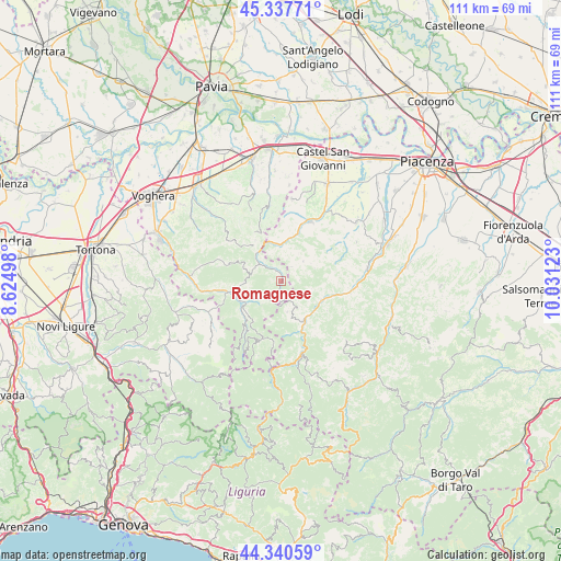
Romagnese GPS coordinates[2]
44° 50' 28.716" North, 9° 19' 41.16" East
| Map corner | latitude | longitude |
|---|---|---|
| Upper-left | 45.33771°, | 8.62498° |
| Center: | 44.84131°, | 9.3281° |
| Lower-right: | 44.34059°, | 10.03123° |
| Map W x H: | 110.9×110.9 km | = 68.9×68.9mi |
| max Lat: | 47.04031° ⇑43.1% North |
| Romagnese: | 44.84131° |
| min Lat: | ⇓56.9% South 35.50142° |
| min Long | Romagnese | max Long |
| 6.69888° | 9.3281° | 18.48682° |
| W 24.1%⇐ | ⇒75.9% E |
Elevation
Elevation of Romagnese is 643 m = 2110 ft, and this is 336.3 m = 1103 ft above average elevation for this country.
| Max E: |
2085 m = 6841 ft | 13.5% |
| Romagnese | 643 m 2110 ft | |
| Avg. | 306.7 m = 1006 ft | |
Min E: |
-4 m = -13 ft | 86.5% |
See also: Italy elevation on elevation.city.
Geographical zone
Romagnese is located in North temperate zone (between Tropic of Cancer and the Arctic Circle). Distance of this Northern Tropic circle is 2380 km =1478.9 mi to South.| Distance of | km | miles | from Romagnese |
|---|---|---|---|
| North Pole | 5021.2 | 3120 | to North |
| Arctic Circle | 2415.3 | 1500.8 | to North |
| Tropic Cancer | 2380 | 1478.9 | to South |
| Equator | 4985.9 | 3098.1 | to South |


Nearby cities:
15 places around Romagnese: (largest is in red/bold)
• Bobbio
9.2 km =5.7 mi,  151°
151°
• Caminata
7.8 km =4.8 mi,  348°
348°
• Caseo
12.1 km =7.5 mi,  339°
339°
• Coli
12.6 km =7.8 mi, 147°
• Menconico
6.3 km =3.9 mi,  217°
217°
• Mombelli
8 km =5 mi,  292°
292°
• Nibbiano
7.1 km =4.4 mi,  0°
0°
• Pecorara
5.8 km =3.6 mi,  48°
48°
• Pometo
10.5 km =6.5 mi, 335°
• Pregola
10.7 km =6.6 mi,  199°
199°
• Ruino
8.8 km =5.5 mi,  332°
332°
• Santa Margherita di Staffora
10.4 km =6.5 mi, 221°
• Varzi
10.5 km =6.5 mi,  258°
258°
• Volpara
12.7 km =7.9 mi, 349°
• Zavattarello
5.7 km =3.5 mi,  301°
301°
Sources, notices
• [Note1] Compared only with cities in Italy existing in our database
• [Src1] Map data: © OpenStreetMap contributors (CC-BY-SA)
• [Src2] Other city data from geonames.org with taken over terms of usage.
• [Src3] Geographical zone / Annual Mean Temperature by Robert A. Rohde @ Wikipedia
