Torriano geodata
Torriano (Lombardy) is a populated place; located in Italy in Europe/Rome (GMT+2) time zone. With population of 901 people, there are 7146 cities with bigger population in this country. Compared to other cities in Italy, 66.5% of cities are located further ↓South; 79.3% of cities are located further →East and 72.2% of cities have higher elevation than Torriano. Note1


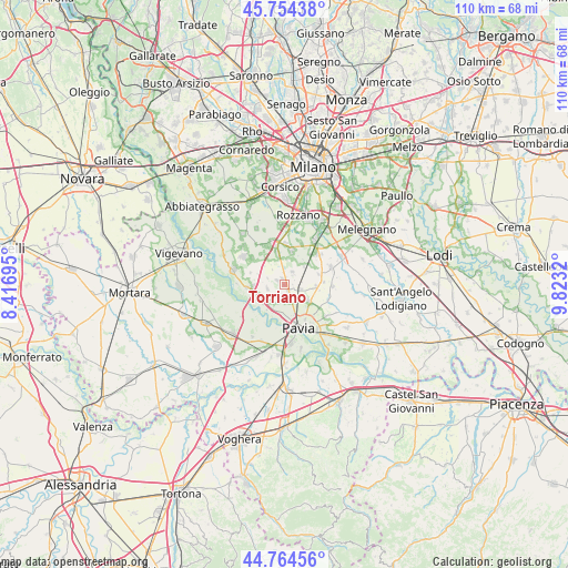
Torriano GPS coordinates[2]
45° 15' 41.868" North, 9° 7' 12.252" East
| Map corner | latitude | longitude |
|---|---|---|
| Upper-left | 45.75438°, | 8.41695° |
| Center: | 45.26163°, | 9.12007° |
| Lower-right: | 44.76456°, | 9.8232° |
| Map W x H: | 110.1×110.1 km | = 68.4×68.4mi |
| max Lat: | 47.04031° ⇑33.5% North |
| Torriano: | 45.26163° |
| min Lat: | ⇓66.5% South 35.50142° |
| min Long | Torriano | max Long |
| 6.69888° | 9.12007° | 18.48682° |
| W 20.7%⇐ | ⇒79.3% E |
Elevation
Elevation of Torriano is 87 m = 285 ft, and this is 219.7 m = 721 ft below average elevation for this country.
| Max E: |
2085 m = 6841 ft | 72.2% |
| Avg. | 306.7 m = 1006 ft | |
| Torriano | 87 m = 285 ft | |
Min E: |
-4 m = -13 ft | 27.8% |
See also: Italy elevation on elevation.city.
Geographical zone
Torriano is located in North temperate zone (between Tropic of Cancer and the Arctic Circle). Distance of this North polar circle is 2368.6 km =1471.8 mi to North.| Distance of | km | miles | from Torriano |
|---|---|---|---|
| North Pole | 4974.4 | 3090.9 | to North |
| Arctic Circle | 2368.6 | 1471.8 | to North |
| Tropic Cancer | 2426.7 | 1507.9 | to South |
| Equator | 5032.6 | 3127.1 | to South |


Nearby cities:
15 places around Torriano: (largest is in red/bold)
• Battuda
3.6 km =2.2 mi,  293°
293°
• Borgarello
2.8 km =1.7 mi,  145°
145°
• Cascine Calderari
3.4 km =2.1 mi,  171°
171°
• Casottole
5.5 km =3.4 mi,  227°
227°
• Certosa di Pavia
1.3 km =0.8 mi,  129°
129°
• Giovenzano
1.3 km =0.8 mi,  346°
346°
• Giussago
3 km =1.9 mi,  31°
31°
• Guinzano
3.1 km =1.9 mi,  100°
100°
• Marcignago
3.3 km =2.1 mi,  253°
253°
• Rognano
3.8 km =2.4 mi,  321°
321°
• San Genesio ed Uniti
5.6 km =3.5 mi,  123°
123°
• Torre d'Isola
5.9 km =3.7 mi,  215°
215°
• Torre del Mangano
1.3 km =0.8 mi,  142°
142°
• Turago Bordone
5.1 km =3.2 mi,  47°
47°
• Vellezzo Bellini
1.7 km =1.1 mi,  300°
300°
Sources, notices
• [Note1] Compared only with cities in Italy existing in our database
• [Src1] Map data: © OpenStreetMap contributors (CC-BY-SA)
• [Src2] Other city data from geonames.org with taken over terms of usage.
• [Src3] Geographical zone / Annual Mean Temperature by Robert A. Rohde @ Wikipedia
