Zeri geodata
Zeri (Tuscany) is a seat of a third-order administrative division; located in Italy in Europe/Rome (GMT+2) time zone. With population of 1,382 people, there are 5402 cities with bigger population in this country. Compared to other cities in Italy, 51.2% of cities are located further ↑North; 70.1% of cities are located further →East and 91.2% of cities have lower elevation than Zeri. Note1


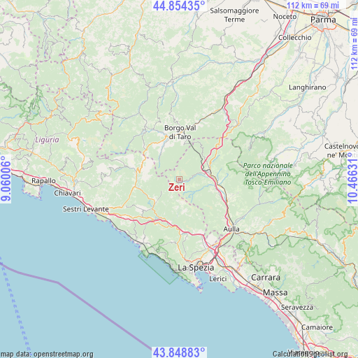
Zeri GPS coordinates[2]
44° 21' 13.5" North, 9° 45' 47.448" East
| Map corner | latitude | longitude |
|---|---|---|
| Upper-left | 44.85435°, | 9.06006° |
| Center: | 44.35375°, | 9.76318° |
| Lower-right: | 43.84883°, | 10.46631° |
| Map W x H: | 111.8×111.8 km | = 69.5×69.5mi |
| max Lat: | 47.04031° ⇑51.2% North |
| Zeri: | 44.35375° |
| min Lat: | ⇓48.8% South 35.50142° |
| min Long | Zeri | max Long |
| 6.69888° | 9.76318° | 18.48682° |
| W 29.9%⇐ | ⇒70.1% E |
Elevation
Elevation of Zeri is 748 m = 2454 ft, and this is 441.3 m = 1448 ft above average elevation for this country.
| Max E: |
2085 m = 6841 ft | 8.8% |
| Zeri | 748 m 2454 ft | |
| Avg. | 306.7 m = 1006 ft | |
Min E: |
-4 m = -13 ft | 91.2% |
See also: Italy elevation on elevation.city.
Geographical zone
Zeri is located in North temperate zone (between Tropic of Cancer and the Arctic Circle). Distance of this Northern Tropic circle is 2325.8 km =1445.2 mi to South.| Distance of | km | miles | from Zeri |
|---|---|---|---|
| North Pole | 5075.4 | 3153.7 | to North |
| Arctic Circle | 2469.5 | 1534.5 | to North |
| Tropic Cancer | 2325.8 | 1445.2 | to South |
| Equator | 4931.7 | 3064.4 | to South |


Nearby cities:
15 places around Zeri: (largest is in red/bold)
• Albareto
11.4 km =7.1 mi,  334°
334°
• Arpiola-Pianfurcano
12 km =7.5 mi,  106°
106°
• Borghetto di Vara
14.8 km =9.2 mi,  193°
193°
• Borgo Val di Taro
15 km =9.3 mi,  1°
1°
• Brugnato
13.4 km =8.3 mi, 193°
• Calice al Cornoviglio
13.6 km =8.5 mi,  154°
154°
• Filattiera
13.8 km =8.6 mi,  101°
101°
• Mulazzo
11 km =6.8 mi, 112°
• Patigno
0.1 km =0.1 mi, 194°
• Pieve di Zignago
8.5 km =5.3 mi, 189°
• Pontremoli
9.5 km =5.9 mi,  75°
75°
• Rocchetta di Vara
11.5 km =7.1 mi,  182°
182°
• Sesta Godano
9.7 km =6 mi,  226°
226°
• Stallone-Talavorno
12.9 km =8 mi, 108°
• Varese Ligure
13.7 km =8.5 mi,  280°
280°
Sources, notices
• [Note1] Compared only with cities in Italy existing in our database
• [Src1] Map data: © OpenStreetMap contributors (CC-BY-SA)
• [Src2] Other city data from geonames.org with taken over terms of usage.
• [Src3] Geographical zone / Annual Mean Temperature by Robert A. Rohde @ Wikipedia
