Filattiera geodata
Filattiera (Tuscany) is a seat of a third-order administrative division; located in Italy in Europe/Rome (GMT+2) time zone. With population of 830 people, there are 7501 cities with bigger population in this country. Compared to other cities in Italy, 51.5% of cities are located further ↑North; 68.4% of cities are located further →East and 61.2% of cities have higher elevation than Filattiera. Note1
Administrative division(s):
- Level 1: Tuscany
- Level 2: Provincia di Massa-Carrara
- Level 3: Filattiera


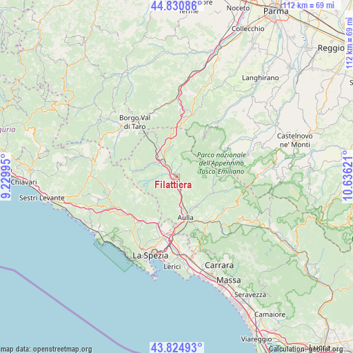
Filattiera GPS coordinates[2]
44° 19' 48.18" North, 9° 55' 59.088" East
| Map corner | latitude | longitude |
|---|---|---|
| Upper-left | 44.83086°, | 9.22995° |
| Center: | 44.33005°, | 9.93308° |
| Lower-right: | 43.82493°, | 10.63621° |
| Map W x H: | 111.8×111.8 km | = 69.5×69.5mi |
| max Lat: | 47.04031° ⇑51.5% North |
| Filattiera: | 44.33005° |
| min Lat: | ⇓48.5% South 35.50142° |
| min Long | Filattiera | max Long |
| 6.69888° | 9.93308° | 18.48682° |
| W 31.6%⇐ | ⇒68.4% E |
Elevation
Elevation of Filattiera is 154 m = 505 ft, and this is 152.7 m = 501 ft below average elevation for this country.
| Max E: |
2085 m = 6841 ft | 61.2% |
| Avg. | 306.7 m = 1006 ft | |
| Filattiera | 154 m = 505 ft | |
Min E: |
-4 m = -13 ft | 38.8% |
See also: Italy elevation on elevation.city.
Geographical zone
Filattiera is located in North temperate zone (between Tropic of Cancer and the Arctic Circle). Distance of this Northern Tropic circle is 2323.1 km =1443.5 mi to South.| Distance of | km | miles | from Filattiera |
|---|---|---|---|
| North Pole | 5078 | 3155.3 | to North |
| Arctic Circle | 2472.1 | 1536.1 | to North |
| Tropic Cancer | 2323.1 | 1443.5 | to South |
| Equator | 4929 | 3062.7 | to South |


Nearby cities:
15 places around Filattiera: (largest is in red/bold)
• Arpiola-Pianfurcano
2.2 km =1.4 mi,  247°
247°
• Bagnone
5.2 km =3.2 mi,  108°
108°
• Barbarasco
9.9 km =6.2 mi,  174°
174°
• Calice al Cornoviglio
12.3 km =7.6 mi,  218°
218°
• Licciana Nardi
11 km =6.8 mi,  131°
131°
• Masero
11.8 km =7.3 mi, 165°
• Montale
13.8 km =8.6 mi,  176°
176°
• Monti
10.9 km =6.8 mi,  146°
146°
• Mulazzo
3.7 km =2.3 mi,  244°
244°
• Podenzana
13.8 km =8.6 mi, 177°
• Pontremoli
6.6 km =4.1 mi,  319°
319°
• Stallone-Talavorno
2 km =1.2 mi, 221°
• Terrarossa
11 km =6.8 mi, 168°
• Tresana
8.6 km =5.3 mi,  190°
190°
• Villafranca in Lunigiana
3.9 km =2.4 mi,  155°
155°
Sources, notices
• [Note1] Compared only with cities in Italy existing in our database
• [Src1] Map data: © OpenStreetMap contributors (CC-BY-SA)
• [Src2] Other city data from geonames.org with taken over terms of usage.
• [Src3] Geographical zone / Annual Mean Temperature by Robert A. Rohde @ Wikipedia
