Albareto geodata
Albareto (Emilia-Romagna) is a seat of a third-order administrative division; located in Italy in Europe/Rome (GMT+2) time zone. With population of 539 people, there are 9552 cities with bigger population in this country. Compared to other cities in Italy, 50.3% of cities are located further ↓South; 70.7% of cities are located further →East and 80% of cities have lower elevation than Albareto. Note1


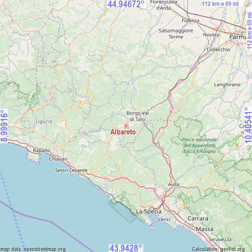
Albareto GPS coordinates[2]
44° 26' 48.912" North, 9° 42' 8.208" East
| Map corner | latitude | longitude |
|---|---|---|
| Upper-left | 44.94672°, | 8.99916° |
| Center: | 44.44692°, | 9.70228° |
| Lower-right: | 43.9428°, | 10.40541° |
| Map W x H: | 111.6×111.6 km | = 69.3×69.3mi |
| max Lat: | 47.04031° ⇑49.7% North |
| Albareto: | 44.44692° |
| min Lat: | ⇓50.3% South 35.50142° |
| min Long | Albareto | max Long |
| 6.69888° | 9.70228° | 18.48682° |
| W 29.3%⇐ | ⇒70.7% E |
Elevation
Elevation of Albareto is 525 m = 1722 ft, and this is 218.3 m = 716 ft above average elevation for this country.
| Max E: |
2085 m = 6841 ft | 20% |
| Albareto | 525 m 1722 ft | |
| Avg. | 306.7 m = 1006 ft | |
Min E: |
-4 m = -13 ft | 80% |
See also: Italy elevation on elevation.city.
Geographical zone
Albareto is located in North temperate zone (between Tropic of Cancer and the Arctic Circle). Distance of this Northern Tropic circle is 2336.1 km =1451.6 mi to South.| Distance of | km | miles | from Albareto |
|---|---|---|---|
| North Pole | 5065 | 3147.2 | to North |
| Arctic Circle | 2459.1 | 1528 | to North |
| Tropic Cancer | 2336.1 | 1451.6 | to South |
| Equator | 4942 | 3070.8 | to South |


Nearby cities:
15 places around Albareto: (largest is in red/bold)
• Arpiola-Pianfurcano
21.4 km =13.3 mi,  130°
130°
• Bardi
20.6 km =12.8 mi,  5°
5°
• Bedonia
8.3 km =5.2 mi,  319°
319°
• Borgo Val di Taro
7.1 km =4.4 mi,  48°
48°
• Carro
20.8 km =12.9 mi,  200°
200°
• Compiano
6.3 km =3.9 mi,  329°
329°
• Maissana
18 km =11.2 mi,  227°
227°
• Mulazzo
20.9 km =13 mi, 134°
• Patigno
11.5 km =7.1 mi,  155°
155°
• Pieve di Zignago
19.1 km =11.9 mi,  169°
169°
• Pontremoli
16.1 km =10 mi,  119°
119°
• Sesta Godano
17.2 km =10.7 mi,  187°
187°
• Tornolo
7.3 km =4.5 mi,  305°
305°
• Varese Ligure
11.6 km =7.2 mi, 227°
• Zeri
11.4 km =7.1 mi,  154°
154°
Sources, notices
• [Note1] Compared only with cities in Italy existing in our database
• [Src1] Map data: © OpenStreetMap contributors (CC-BY-SA)
• [Src2] Other city data from geonames.org with taken over terms of usage.
• [Src3] Geographical zone / Annual Mean Temperature by Robert A. Rohde @ Wikipedia
