Travo geodata
Travo (Emilia-Romagna) is a seat of a third-order administrative division; located in Italy in Europe/Rome (GMT+2) time zone. With population of 708 people, there are 8242 cities with bigger population in this country. Compared to other cities in Italy, 57.3% of cities are located further ↓South; 72.7% of cities are located further →East and 58.3% of cities have higher elevation than Travo. Note1


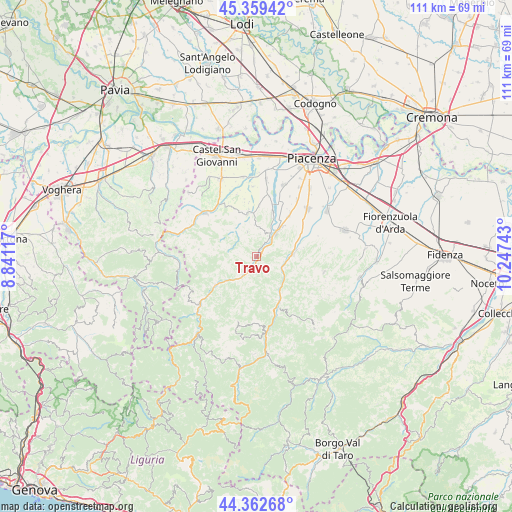
Travo GPS coordinates[2]
44° 51' 47.556" North, 9° 32' 39.48" East
| Map corner | latitude | longitude |
|---|---|---|
| Upper-left | 45.35942°, | 8.84117° |
| Center: | 44.86321°, | 9.5443° |
| Lower-right: | 44.36268°, | 10.24743° |
| Map W x H: | 110.8×110.8 km | = 68.8×68.8mi |
| max Lat: | 47.04031° ⇑42.7% North |
| Travo: | 44.86321° |
| min Lat: | ⇓57.3% South 35.50142° |
| min Long | Travo | max Long |
| 6.69888° | 9.5443° | 18.48682° |
| W 27.3%⇐ | ⇒72.7% E |
Elevation
Elevation of Travo is 177 m = 581 ft, and this is 129.7 m = 426 ft below average elevation for this country.
| Max E: |
2085 m = 6841 ft | 58.3% |
| Avg. | 306.7 m = 1006 ft | |
| Travo | 177 m = 581 ft | |
Min E: |
-4 m = -13 ft | 41.7% |
See also: Italy elevation on elevation.city.
Geographical zone
Travo is located in North temperate zone (between Tropic of Cancer and the Arctic Circle). Distance of this Northern Tropic circle is 2382.4 km =1480.4 mi to South.| Distance of | km | miles | from Travo |
|---|---|---|---|
| North Pole | 5018.7 | 3118.5 | to North |
| Arctic Circle | 2412.9 | 1499.3 | to North |
| Tropic Cancer | 2382.4 | 1480.4 | to South |
| Equator | 4988.3 | 3099.6 | to South |


Nearby cities:
15 places around Travo: (largest is in red/bold)
• Agazzano
9.6 km =6 mi,  347°
347°
• Bettola
10.7 km =6.6 mi,  151°
151°
• Gazzola
10.8 km =6.7 mi,  1°
1°
• Gropparello
14.9 km =9.3 mi,  102°
102°
• Niviano
10.8 km =6.7 mi,  37°
37°
• Pecorara
12.7 km =7.9 mi,  276°
276°
• Pianello Val Tidone
14.4 km =8.9 mi,  310°
310°
• Piozzano
7.9 km =4.9 mi,  330°
330°
• Podenzano
14.9 km =9.3 mi,  47°
47°
• Ponte dell'Olio
7.9 km =4.9 mi,  86°
86°
• Rivergaro
7.5 km =4.7 mi, 39°
• San Giovanni-San Bernardino
9.3 km =5.8 mi, 146°
• Settima
15 km =9.3 mi, 35°
• Trevozzo
15.2 km =9.4 mi, 309°
• Vigolzone
11.3 km =7 mi,  60°
60°
Sources, notices
• [Note1] Compared only with cities in Italy existing in our database
• [Src1] Map data: © OpenStreetMap contributors (CC-BY-SA)
• [Src2] Other city data from geonames.org with taken over terms of usage.
• [Src3] Geographical zone / Annual Mean Temperature by Robert A. Rohde @ Wikipedia
