Pederiva geodata
Pederiva (Veneto) is a seat of a third-order administrative division; located in Italy in Europe/Rome (GMT+2) time zone. With population of 771 people, there are 7811 cities with bigger population in this country. Compared to other cities in Italy, 71% of cities are located further ↓South; 51% of cities are located further →East and 80.9% of cities have higher elevation than Pederiva. Note1


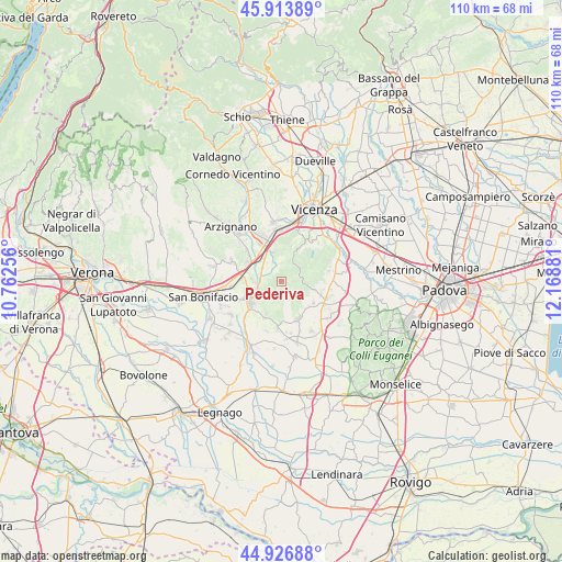
Pederiva GPS coordinates[2]
45° 25' 21.144" North, 11° 27' 56.448" East
| Map corner | latitude | longitude |
|---|---|---|
| Upper-left | 45.91389°, | 10.76256° |
| Center: | 45.42254°, | 11.46568° |
| Lower-right: | 44.92688°, | 12.16881° |
| Map W x H: | 109.7×109.7 km | = 68.2×68.2mi |
| max Lat: | 47.04031° ⇑29% North |
| Pederiva: | 45.42254° |
| min Lat: | ⇓71% South 35.50142° |
| min Long | Pederiva | max Long |
| 6.69888° | 11.46568° | 18.48682° |
| W 49%⇐ | ⇒51% E |
Elevation
Elevation of Pederiva is 46 m = 151 ft, and this is 260.7 m = 855 ft below average elevation for this country.
| Max E: |
2085 m = 6841 ft | 80.9% |
| Avg. | 306.7 m = 1006 ft | |
| Pederiva | 46 m = 151 ft | |
Min E: |
-4 m = -13 ft | 19.1% |
See also: Italy elevation on elevation.city.
Geographical zone
Pederiva is located in North temperate zone (between Tropic of Cancer and the Arctic Circle). Distance of this North polar circle is 2350.7 km =1460.7 mi to North.| Distance of | km | miles | from Pederiva |
|---|---|---|---|
| North Pole | 4956.5 | 3079.8 | to North |
| Arctic Circle | 2350.7 | 1460.7 | to North |
| Tropic Cancer | 2444.6 | 1519 | to South |
| Equator | 5050.5 | 3138.2 | to South |


Nearby cities:
15 places around Pederiva: (largest is in red/bold)
• Alonte
7 km =4.3 mi,  205°
205°
• Barbarano Vicentino
6.2 km =3.9 mi,  103°
103°
• Brendola
6.5 km =4 mi,  341°
341°
• Grancona
1.1 km =0.7 mi,  266°
266°
• Lonigo
7.6 km =4.7 mi,  237°
237°
• Meledo
4.3 km =2.7 mi,  294°
294°
• Montebello Vicentino
7.6 km =4.7 mi,  302°
302°
• Monticello di Fara
5.9 km =3.7 mi,  276°
276°
• Mossano
6.9 km =4.3 mi,  92°
92°
• San Germano dei Berici
2.3 km =1.4 mi,  169°
169°
• Sarego
5.2 km =3.2 mi,  251°
251°
• Sossano
8 km =5 mi,  155°
155°
• Villaga
5.8 km =3.6 mi,  112°
112°
• Vo
4.1 km =2.5 mi, 337°
• Zovencedo
3.1 km =1.9 mi,  76°
76°
Sources, notices
• [Note1] Compared only with cities in Italy existing in our database
• [Src1] Map data: © OpenStreetMap contributors (CC-BY-SA)
• [Src2] Other city data from geonames.org with taken over terms of usage.
• [Src3] Geographical zone / Annual Mean Temperature by Robert A. Rohde @ Wikipedia
