Cremenaga geodata
Cremenaga (Lombardy) is a seat of a third-order administrative division; located in Italy in Europe/Rome (GMT+2) time zone. With population of 768 people, there are 7830 cities with bigger population in this country. Compared to other cities in Italy, 91.7% of cities are located further ↓South; 84.1% of cities are located further →East and 53.6% of cities have lower elevation than Cremenaga. Note1


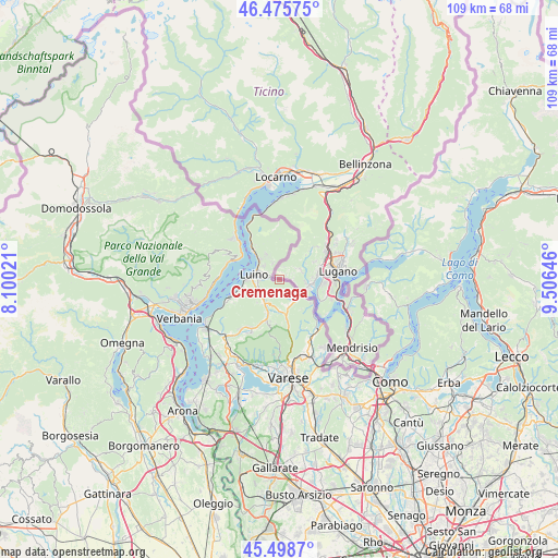
Cremenaga GPS coordinates[2]
45° 59' 21.768" North, 8° 48' 11.988" East
| Map corner | latitude | longitude |
|---|---|---|
| Upper-left | 46.47575°, | 8.10021° |
| Center: | 45.98938°, | 8.80333° |
| Lower-right: | 45.4987°, | 9.50646° |
| Map W x H: | 108.6×108.6 km | = 67.5×67.5mi |
| max Lat: | 47.04031° ⇑8.3% North |
| Cremenaga: | 45.98938° |
| min Lat: | ⇓91.7% South 35.50142° |
| min Long | Cremenaga | max Long |
| 6.69888° | 8.80333° | 18.48682° |
| W 15.9%⇐ | ⇒84.1% E |
Elevation
Elevation of Cremenaga is 257 m = 843 ft, and this is 49.7 m = 163 ft below average elevation for this country.
| Max E: |
2085 m = 6841 ft | 46.4% |
| Avg. | 306.7 m = 1006 ft | |
| Cremenaga | 257 m = 843 ft | |
Min E: |
-4 m = -13 ft | 53.6% |
See also: Italy elevation on elevation.city.
Geographical zone
Cremenaga is located in North temperate zone (between Tropic of Cancer and the Arctic Circle). Distance of this North polar circle is 2287.6 km =1421.4 mi to North.| Distance of | km | miles | from Cremenaga |
|---|---|---|---|
| North Pole | 4893.5 | 3040.7 | to North |
| Arctic Circle | 2287.6 | 1421.4 | to North |
| Tropic Cancer | 2507.6 | 1558.1 | to South |
| Equator | 5113.5 | 3177.4 | to South |


Nearby cities:
15 places around Cremenaga: (largest is in red/bold)
• Agra
5.9 km =3.7 mi,  332°
332°
• Cadegliano-Viconago
4.5 km =2.8 mi,  137°
137°
• Colmegna
5.6 km =3.5 mi,  319°
319°
• Cugliate-Fabiasco
5 km =3.1 mi,  166°
166°
• Cunardo
6.1 km =3.8 mi,  176°
176°
• Dumenza
3.7 km =2.3 mi,  339°
339°
• Germignaga
6.1 km =3.8 mi,  271°
271°
• Grantola
5 km =3.1 mi,  206°
206°
• Lavena Ponte Tresa
4.8 km =3 mi,  120°
120°
• Luino
4.7 km =2.9 mi,  287°
287°
• Marchirolo
5.2 km =3.2 mi,  153°
153°
• Mesenzana
5.2 km =3.2 mi,  215°
215°
• Montegrino Valtravaglia
3.3 km =2.1 mi,  238°
238°
• Piano
4.8 km =3 mi,  234°
234°
• Poppino
4.1 km =2.5 mi,  313°
313°
Sources, notices
• [Note1] Compared only with cities in Italy existing in our database
• [Src1] Map data: © OpenStreetMap contributors (CC-BY-SA)
• [Src2] Other city data from geonames.org with taken over terms of usage.
• [Src3] Geographical zone / Annual Mean Temperature by Robert A. Rohde @ Wikipedia
