Montanera geodata
Montanera (Piedmont) is a seat of a third-order administrative division; located in Italy in Europe/Rome (GMT+2) time zone. With population of 493 people, there are 9955 cities with bigger population in this country. Compared to other cities in Italy, 50.5% of cities are located further ↓South; 96.5% of cities are located further →East and 72.7% of cities have lower elevation than Montanera. Note1


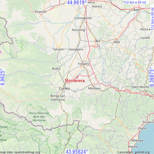
Montanera GPS coordinates[2]
44° 27' 44.028" North, 7° 39' 56.268" East
| Map corner | latitude | longitude |
|---|---|---|
| Upper-left | 44.9619°, | 6.9625° |
| Center: | 44.46223°, | 7.66563° |
| Lower-right: | 43.95824°, | 8.36875° |
| Map W x H: | 111.6×111.6 km | = 69.3×69.3mi |
| max Lat: | 47.04031° ⇑49.5% North |
| Montanera: | 44.46223° |
| min Lat: | ⇓50.5% South 35.50142° |
| min Long | Montanera | max Long |
| 6.69888° | 7.66563° | 18.48682° |
| W 3.5%⇐ | ⇒96.5% E |
Elevation
Elevation of Montanera is 422 m = 1385 ft, and this is 115.3 m = 378 ft above average elevation for this country.
| Max E: |
2085 m = 6841 ft | 27.3% |
| Montanera | 422 m 1385 ft | |
| Avg. | 306.7 m = 1006 ft | |
Min E: |
-4 m = -13 ft | 72.7% |
See also: Italy elevation on elevation.city.
Geographical zone
Montanera is located in North temperate zone (between Tropic of Cancer and the Arctic Circle). Distance of this Northern Tropic circle is 2337.8 km =1452.6 mi to South.| Distance of | km | miles | from Montanera |
|---|---|---|---|
| North Pole | 5063.3 | 3146.2 | to North |
| Arctic Circle | 2457.4 | 1527 | to North |
| Tropic Cancer | 2337.8 | 1452.6 | to South |
| Equator | 4943.7 | 3071.9 | to South |


Nearby cities:
15 places around Montanera: (largest is in red/bold)
• Beinette
11.1 km =6.9 mi,  188°
188°
• Castelletto Stura
2.9 km =1.8 mi,  225°
225°
• Centallo
7.6 km =4.7 mi,  305°
305°
• Crava
7.2 km =4.5 mi,  119°
119°
• Fossano
10.7 km =6.6 mi,  23°
23°
• Levaldigi
11.1 km =6.9 mi,  341°
341°
• Margarita
6.7 km =4.2 mi,  166°
166°
• Morozzo
5.6 km =3.5 mi,  141°
141°
• Pianfei
10.7 km =6.6 mi,  160°
160°
• Roata Chiusani
5.8 km =3.6 mi,  269°
269°
• Rocca De' Baldi
8.7 km =5.4 mi, 119°
• San Biagio
4.9 km =3 mi,  296°
296°
• Sant'Albano Stura
6.8 km =4.2 mi,  41°
41°
• Tarantasca
10.2 km =6.3 mi,  289°
289°
• Trinità
8.8 km =5.5 mi,  55°
55°
Sources, notices
• [Note1] Compared only with cities in Italy existing in our database
• [Src1] Map data: © OpenStreetMap contributors (CC-BY-SA)
• [Src2] Other city data from geonames.org with taken over terms of usage.
• [Src3] Geographical zone / Annual Mean Temperature by Robert A. Rohde @ Wikipedia
