Airali geodata
Airali (Piedmont) is a seat of a third-order administrative division; located in Italy in Europe/Rome (GMT+2) time zone. With population of 5,619 people, there are 1748 cities with bigger population in this country. Compared to other cities in Italy, 56.5% of cities are located further ↓South; 99.2% of cities are located further →East and 76.4% of cities have lower elevation than Airali. Note1


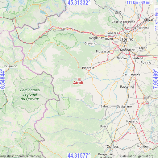
Airali GPS coordinates[2]
44° 49' 0.12" North, 7° 15' 5.652" East
| Map corner | latitude | longitude |
|---|---|---|
| Upper-left | 45.31332°, | 6.54844° |
| Center: | 44.8167°, | 7.25157° |
| Lower-right: | 44.31577°, | 7.95469° |
| Map W x H: | 110.9×110.9 km | = 68.9×68.9mi |
| max Lat: | 47.04031° ⇑43.5% North |
| Airali: | 44.8167° |
| min Lat: | ⇓56.5% South 35.50142° |
| min Long | Airali | max Long |
| 6.69888° | 7.25157° | 18.48682° |
| W 0.8%⇐ | ⇒99.2% E |
Elevation
Elevation of Airali is 472 m = 1549 ft, and this is 165.3 m = 542 ft above average elevation for this country.
| Max E: |
2085 m = 6841 ft | 23.6% |
| Airali | 472 m 1549 ft | |
| Avg. | 306.7 m = 1006 ft | |
Min E: |
-4 m = -13 ft | 76.4% |
See also: Italy elevation on elevation.city.
Geographical zone
Airali is located in North temperate zone (between Tropic of Cancer and the Arctic Circle). Distance of this Northern Tropic circle is 2377.2 km =1477.1 mi to South.| Distance of | km | miles | from Airali |
|---|---|---|---|
| North Pole | 5023.9 | 3121.7 | to North |
| Arctic Circle | 2418 | 1502.5 | to North |
| Tropic Cancer | 2377.2 | 1477.1 | to South |
| Equator | 4983.1 | 3096.4 | to South |


Nearby cities:
15 places around Airali: (largest is in red/bold)
• Angrogna
3.7 km =2.3 mi,  324°
324°
• Bagnolo Piemonte
8 km =5 mi,  141°
141°
• Bibiana
3.5 km =2.2 mi,  124°
124°
• Bricherasio
4.1 km =2.5 mi,  79°
79°
• Campiglione
5.9 km =3.7 mi,  105°
105°
• Luserna
1.1 km =0.7 mi,  203°
203°
• Lusernetta
1.6 km =1 mi,  194°
194°
• Miradolo
7.6 km =4.7 mi,  33°
33°
• Osasco
8.1 km =5 mi,  63°
63°
• Porte
8 km =5 mi,  10°
10°
• Prarostino
5.7 km =3.5 mi, 12°
• Rorà
5 km =3.1 mi,  236°
236°
• San Secondo di Pinerolo
6.7 km =4.2 mi, 33°
• Torre Pellice
2.8 km =1.7 mi,  279°
279°
• Villar Pellice
7.3 km =4.5 mi,  263°
263°
Sources, notices
• [Note1] Compared only with cities in Italy existing in our database
• [Src1] Map data: © OpenStreetMap contributors (CC-BY-SA)
• [Src2] Other city data from geonames.org with taken over terms of usage.
• [Src3] Geographical zone / Annual Mean Temperature by Robert A. Rohde @ Wikipedia
