Centobuchi geodata
Centobuchi (The Marches) is a populated place; located in Italy in Europe/Rome (GMT+2) time zone. With population of 8,384 people, there are 1148 cities with bigger population in this country. Compared to other cities in Italy, 64% of cities are located further ↑North; 77% of cities are located further ←West and 92.6% of cities have higher elevation than Centobuchi. Note1
Administrative division(s):
- Level 1: The Marches
- Level 2: Provincia di Ascoli Piceno
- Level 3: Monteprandone


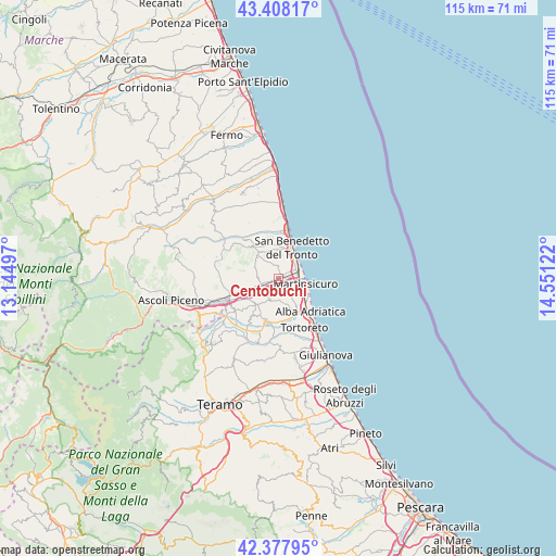
Centobuchi GPS coordinates[2]
42° 53' 42.756" North, 13° 50' 53.124" East
| Map corner | latitude | longitude |
|---|---|---|
| Upper-left | 43.40817°, | 13.14497° |
| Center: | 42.89521°, | 13.84809° |
| Lower-right: | 42.37795°, | 14.55122° |
| Map W x H: | 114.5×114.5 km | = 71.1×71.1mi |
| max Lat: | 47.04031° ⇑64% North |
| Centobuchi: | 42.89521° |
| min Lat: | ⇓36% South 35.50142° |
| min Long | Centobuchi | max Long |
| 6.69888° | 13.84809° | 18.48682° |
| W 77%⇐ | ⇒23% E |
Elevation
Elevation of Centobuchi is 13 m = 43 ft, and this is 293.7 m = 964 ft below average elevation for this country.
| Max E: |
2085 m = 6841 ft | 92.6% |
| Avg. | 306.7 m = 1006 ft | |
| Centobuchi | 13 m = 43 ft | |
Min E: |
-4 m = -13 ft | 7.4% |
See also: Italy elevation on elevation.city.
Geographical zone
Centobuchi is located in North temperate zone (between Tropic of Cancer and the Arctic Circle). Distance of this Northern Tropic circle is 2163.6 km =1344.4 mi to South.| Distance of | km | miles | from Centobuchi |
|---|---|---|---|
| North Pole | 5237.6 | 3254.5 | to North |
| Arctic Circle | 2631.7 | 1635.3 | to North |
| Tropic Cancer | 2163.6 | 1344.4 | to South |
| Equator | 4769.5 | 2963.6 | to South |


Nearby cities:
15 places around Centobuchi: (largest is in red/bold)
• Acquaviva Picena
5.4 km =3.4 mi,  337°
337°
• Colli del Tronto
8.4 km =5.2 mi,  256°
256°
• Colonnella
3.1 km =1.9 mi,  145°
145°
• Controguerra
5.2 km =3.2 mi,  208°
208°
• Corropoli
7.6 km =4.7 mi,  188°
188°
• Martinsicuro
5.6 km =3.5 mi,  107°
107°
• Monsampolo del Tronto
4.5 km =2.8 mi,  273°
273°
• Monteprandone
2.9 km =1.8 mi,  345°
345°
• Pagliare
7.1 km =4.4 mi,  245°
245°
• San Benedetto del Tronto
7.2 km =4.5 mi,  18°
18°
• San Giovanni
2.3 km =1.4 mi, 113°
• Spinetoli
6.8 km =4.2 mi, 264°
• Stella
3.3 km =2.1 mi, 253°
• Villa Rosa
7.7 km =4.8 mi,  130°
130°
• Villa San Giuseppe
8.9 km =5.5 mi, 250°
Sources, notices
• [Note1] Compared only with cities in Italy existing in our database
• [Src1] Map data: © OpenStreetMap contributors (CC-BY-SA)
• [Src2] Other city data from geonames.org with taken over terms of usage.
• [Src3] Geographical zone / Annual Mean Temperature by Robert A. Rohde @ Wikipedia
