Roveleto geodata
Roveleto (Emilia-Romagna) is a seat of a third-order administrative division; located in Italy in Europe/Rome (GMT+2) time zone. With population of 4,782 people, there are 2044 cities with bigger population in this country. Compared to other cities in Italy, 59.2% of cities are located further ↓South; 69.3% of cities are located further →East and 76.5% of cities have higher elevation than Roveleto. Note1


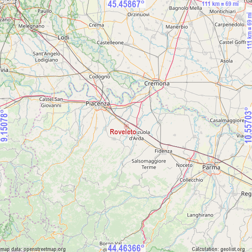
Roveleto GPS coordinates[2]
44° 57' 47.952" North, 9° 51' 14.04" East
| Map corner | latitude | longitude |
|---|---|---|
| Upper-left | 45.45867°, | 9.15078° |
| Center: | 44.96332°, | 9.8539° |
| Lower-right: | 44.46366°, | 10.55703° |
| Map W x H: | 110.6×110.6 km | = 68.7×68.7mi |
| max Lat: | 47.04031° ⇑40.8% North |
| Roveleto: | 44.96332° |
| min Lat: | ⇓59.2% South 35.50142° |
| min Long | Roveleto | max Long |
| 6.69888° | 9.8539° | 18.48682° |
| W 30.7%⇐ | ⇒69.3% E |
Elevation
Elevation of Roveleto is 67 m = 220 ft, and this is 239.7 m = 786 ft below average elevation for this country.
| Max E: |
2085 m = 6841 ft | 76.5% |
| Avg. | 306.7 m = 1006 ft | |
| Roveleto | 67 m = 220 ft | |
Min E: |
-4 m = -13 ft | 23.5% |
See also: Italy elevation on elevation.city.
Geographical zone
Roveleto is located in North temperate zone (between Tropic of Cancer and the Arctic Circle). Distance of this Northern Tropic circle is 2393.5 km =1487.3 mi to South.| Distance of | km | miles | from Roveleto |
|---|---|---|---|
| North Pole | 5007.6 | 3111.6 | to North |
| Arctic Circle | 2401.7 | 1492.3 | to North |
| Tropic Cancer | 2393.5 | 1487.3 | to South |
| Equator | 4999.5 | 3106.5 | to South |


Nearby cities:
15 places around Roveleto: (largest is in red/bold)
• Alseno
11.3 km =7 mi,  130°
130°
• Besenzone
8.5 km =5.3 mi,  71°
71°
• Caorso
9.7 km =6 mi,  9°
9°
• Carpaneto Piacentino
7.6 km =4.7 mi,  223°
223°
• Castell'Arquato
12.2 km =7.6 mi,  172°
172°
• Cortemaggiore
6.7 km =4.2 mi,  61°
61°
• Fiorenzuola d'Arda
6.4 km =4 mi, 132°
• Lusurasco
9.4 km =5.8 mi,  151°
151°
• Pontenure
6.3 km =3.9 mi,  308°
308°
• San Giorgio Piacentino
9.2 km =5.7 mi,  262°
262°
• San Nazzaro
13.1 km =8.1 mi,  15°
15°
• San Pietro in Cerro
9.9 km =6.2 mi,  49°
49°
• San Polo
9.1 km =5.7 mi,  280°
280°
• Vigolo Marchese
9.3 km =5.8 mi,  184°
184°
• Villanova
13.3 km =8.3 mi, 58°
Sources, notices
• [Note1] Compared only with cities in Italy existing in our database
• [Src1] Map data: © OpenStreetMap contributors (CC-BY-SA)
• [Src2] Other city data from geonames.org with taken over terms of usage.
• [Src3] Geographical zone / Annual Mean Temperature by Robert A. Rohde @ Wikipedia
