Caorso geodata
Caorso (Emilia-Romagna) is a seat of a third-order administrative division; located in Italy in Europe/Rome (GMT+2) time zone. With population of 3,368 people, there are 2783 cities with bigger population in this country. Compared to other cities in Italy, 61.2% of cities are located further ↓South; 69.1% of cities are located further →East and 80.3% of cities have higher elevation than Caorso. Note1


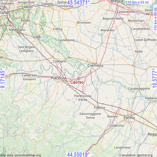
Caorso GPS coordinates[2]
45° 2' 56.796" North, 9° 52' 28.452" East
| Map corner | latitude | longitude |
|---|---|---|
| Upper-left | 45.54371°, | 9.17145° |
| Center: | 45.04911°, | 9.87457° |
| Lower-right: | 44.55019°, | 10.5777° |
| Map W x H: | 110.5×110.5 km | = 68.7×68.7mi |
| max Lat: | 47.04031° ⇑38.8% North |
| Caorso: | 45.04911° |
| min Lat: | ⇓61.2% South 35.50142° |
| min Long | Caorso | max Long |
| 6.69888° | 9.87457° | 18.48682° |
| W 30.9%⇐ | ⇒69.1% E |
Elevation
Elevation of Caorso is 48 m = 157 ft, and this is 258.7 m = 849 ft below average elevation for this country.
| Max E: |
2085 m = 6841 ft | 80.3% |
| Avg. | 306.7 m = 1006 ft | |
| Caorso | 48 m = 157 ft | |
Min E: |
-4 m = -13 ft | 19.7% |
See also: Italy elevation on elevation.city.
Geographical zone
Caorso is located in North temperate zone (between Tropic of Cancer and the Arctic Circle). Distance of this North polar circle is 2392.2 km =1486.4 mi to North.| Distance of | km | miles | from Caorso |
|---|---|---|---|
| North Pole | 4998.1 | 3105.7 | to North |
| Arctic Circle | 2392.2 | 1486.4 | to North |
| Tropic Cancer | 2403.1 | 1493.2 | to South |
| Equator | 5009 | 3112.4 | to South |


Nearby cities:
15 places around Caorso: (largest is in red/bold)
• Besenzone
9.4 km =5.8 mi,  137°
137°
• Caselle Landi
8.6 km =5.3 mi,  313°
313°
• Castelnuovo Bocca d'Adda
7 km =4.3 mi,  352°
352°
• Castelvetro Piacentino
10.8 km =6.7 mi,  57°
57°
• Cortemaggiore
7.6 km =4.7 mi,  146°
146°
• Meleti
8.4 km =5.2 mi,  338°
338°
• Monticelli d'Ongina
6.4 km =4 mi,  46°
46°
• Mortizza
9.8 km =6.1 mi,  288°
288°
• Olza-Fogarole
9.4 km =5.8 mi, 47°
• Pontenure
8.6 km =5.3 mi,  229°
229°
• Roveleto
9.7 km =6 mi,  189°
189°
• San Giuliano
9.7 km =6 mi,  76°
76°
• San Nazzaro
3.6 km =2.2 mi,  32°
32°
• San Pietro in Cerro
6.7 km =4.2 mi,  117°
117°
• Villanova
10.1 km =6.3 mi,  104°
104°
Sources, notices
• [Note1] Compared only with cities in Italy existing in our database
• [Src1] Map data: © OpenStreetMap contributors (CC-BY-SA)
• [Src2] Other city data from geonames.org with taken over terms of usage.
• [Src3] Geographical zone / Annual Mean Temperature by Robert A. Rohde @ Wikipedia
