Lusurasco geodata
Lusurasco (Emilia-Romagna) is a populated place; located in Italy in Europe/Rome (GMT+2) time zone. With population of 682 people, there are 8413 cities with bigger population in this country. Compared to other cities in Italy, 57.7% of cities are located further ↓South; 68.7% of cities are located further →East and 66.9% of cities have higher elevation than Lusurasco. Note1


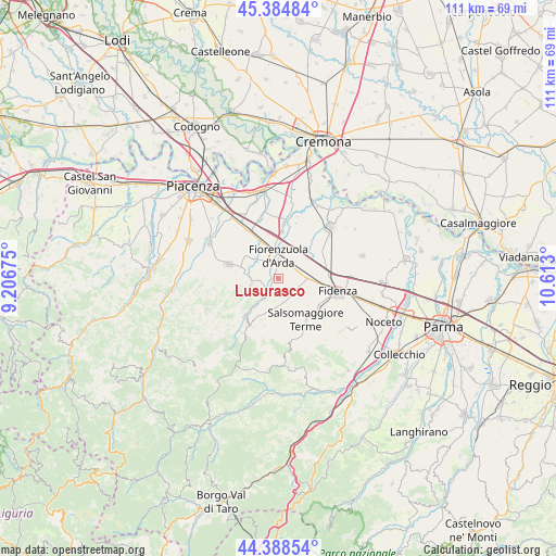
Lusurasco GPS coordinates[2]
44° 53' 19.86" North, 9° 54' 35.532" East
| Map corner | latitude | longitude |
|---|---|---|
| Upper-left | 45.38484°, | 9.20675° |
| Center: | 44.88885°, | 9.90987° |
| Lower-right: | 44.38854°, | 10.613° |
| Map W x H: | 110.8×110.8 km | = 68.8×68.8mi |
| max Lat: | 47.04031° ⇑42.3% North |
| Lusurasco: | 44.88885° |
| min Lat: | ⇓57.7% South 35.50142° |
| min Long | Lusurasco | max Long |
| 6.69888° | 9.90987° | 18.48682° |
| W 31.3%⇐ | ⇒68.7% E |
Elevation
Elevation of Lusurasco is 116 m = 381 ft, and this is 190.7 m = 626 ft below average elevation for this country.
| Max E: |
2085 m = 6841 ft | 66.9% |
| Avg. | 306.7 m = 1006 ft | |
| Lusurasco | 116 m = 381 ft | |
Min E: |
-4 m = -13 ft | 33.1% |
See also: Italy elevation on elevation.city.
Geographical zone
Lusurasco is located in North temperate zone (between Tropic of Cancer and the Arctic Circle). Distance of this Northern Tropic circle is 2385.3 km =1482.2 mi to South.| Distance of | km | miles | from Lusurasco |
|---|---|---|---|
| North Pole | 5015.9 | 3116.7 | to North |
| Arctic Circle | 2410 | 1497.5 | to North |
| Tropic Cancer | 2385.3 | 1482.2 | to South |
| Equator | 4991.2 | 3101.4 | to South |


Nearby cities:
15 places around Lusurasco: (largest is in red/bold)
• Alseno
4.4 km =2.7 mi,  77°
77°
• Bagni di Tabiano
12.6 km =7.8 mi,  135°
135°
• Besenzone
11.5 km =7.1 mi,  18°
18°
• Busseto
14.5 km =9 mi,  46°
46°
• Carpaneto Piacentino
10.1 km =6.3 mi,  285°
285°
• Castell'Arquato
4.8 km =3 mi,  217°
217°
• Castelnuovo Fogliani
5.2 km =3.2 mi,  106°
106°
• Cortemaggiore
11.5 km =7.1 mi,  7°
7°
• Fidenza
12.1 km =7.5 mi,  101°
101°
• Fiorenzuola d'Arda
4 km =2.5 mi,  3°
3°
• Lugagnano Val d'Arda
9.7 km =6 mi, 221°
• Roveleto
9.4 km =5.8 mi,  331°
331°
• Salsomaggiore Terme
10.1 km =6.3 mi, 143°
• Vernasca
11.8 km =7.3 mi,  211°
211°
• Vigolo Marchese
5.3 km =3.3 mi,  258°
258°
Sources, notices
• [Note1] Compared only with cities in Italy existing in our database
• [Src1] Map data: © OpenStreetMap contributors (CC-BY-SA)
• [Src2] Other city data from geonames.org with taken over terms of usage.
• [Src3] Geographical zone / Annual Mean Temperature by Robert A. Rohde @ Wikipedia
