Pontenure geodata
Pontenure (Emilia-Romagna) is a seat of a third-order administrative division; located in Italy in Europe/Rome (GMT+2) time zone. With population of 5,385 people, there are 1816 cities with bigger population in this country. Compared to other cities in Italy, 59.9% of cities are located further ↓South; 69.8% of cities are located further →East and 77.2% of cities have higher elevation than Pontenure. Note1
Administrative division(s):
- Level 1: Emilia-Romagna
- Level 2: Provincia di Piacenza
- Level 3: Pontenure


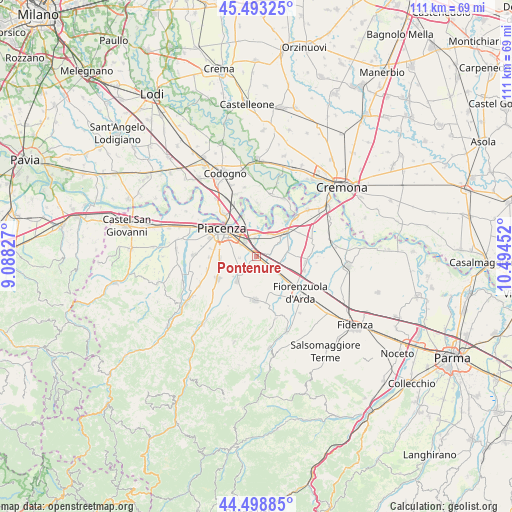
Pontenure GPS coordinates[2]
44° 59' 53.556" North, 9° 47' 29.004" East
| Map corner | latitude | longitude |
|---|---|---|
| Upper-left | 45.49325°, | 9.08827° |
| Center: | 44.99821°, | 9.79139° |
| Lower-right: | 44.49885°, | 10.49452° |
| Map W x H: | 110.6×110.6 km | = 68.7×68.7mi |
| max Lat: | 47.04031° ⇑40.1% North |
| Pontenure: | 44.99821° |
| min Lat: | ⇓59.9% South 35.50142° |
| min Long | Pontenure | max Long |
| 6.69888° | 9.79139° | 18.48682° |
| W 30.2%⇐ | ⇒69.8% E |
Elevation
Elevation of Pontenure is 63 m = 207 ft, and this is 243.7 m = 800 ft below average elevation for this country.
| Max E: |
2085 m = 6841 ft | 77.2% |
| Avg. | 306.7 m = 1006 ft | |
| Pontenure | 63 m = 207 ft | |
Min E: |
-4 m = -13 ft | 22.8% |
See also: Italy elevation on elevation.city.
Geographical zone
Pontenure is located in North temperate zone (between Tropic of Cancer and the Arctic Circle). Distance of this Northern Tropic circle is 2397.4 km =1489.7 mi to South.| Distance of | km | miles | from Pontenure |
|---|---|---|---|
| North Pole | 5003.7 | 3109.2 | to North |
| Arctic Circle | 2397.8 | 1489.9 | to North |
| Tropic Cancer | 2397.4 | 1489.7 | to South |
| Equator | 5003.3 | 3108.9 | to South |


Nearby cities:
15 places around Pontenure: (largest is in red/bold)
• Caorso
8.6 km =5.3 mi,  49°
49°
• Carpaneto Piacentino
9.4 km =5.8 mi,  182°
182°
• Caselle Landi
11.6 km =7.2 mi,  1°
1°
• Cortemaggiore
10.8 km =6.7 mi,  93°
93°
• Mortizza
9.2 km =5.7 mi,  342°
342°
• Piacenza
9.8 km =6.1 mi,  308°
308°
• Pittolo
10.2 km =6.3 mi,  279°
279°
• Podenzano
9.8 km =6.1 mi,  240°
240°
• Quarto
10.1 km =6.3 mi,  269°
269°
• Roveleto
6.3 km =3.9 mi,  128°
128°
• San Giorgio Piacentino
6.7 km =4.2 mi,  219°
219°
• San Nazzaro
12.1 km =7.5 mi,  44°
44°
• San Polo
4.5 km =2.8 mi, 241°
• San Rocco al Porto
11.9 km =7.4 mi,  321°
321°
• Settima
11.1 km =6.9 mi,  255°
255°
Sources, notices
• [Note1] Compared only with cities in Italy existing in our database
• [Src1] Map data: © OpenStreetMap contributors (CC-BY-SA)
• [Src2] Other city data from geonames.org with taken over terms of usage.
• [Src3] Geographical zone / Annual Mean Temperature by Robert A. Rohde @ Wikipedia
