Galta geodata
Galta (Veneto) is a populated place; located in Italy in Europe/Rome (GMT+2) time zone. With population of 2,295 people, there are 3768 cities with bigger population in this country. Compared to other cities in Italy, 70% of cities are located further ↓South; 56.2% of cities are located further ←West and 97.8% of cities have higher elevation than Galta. Note1


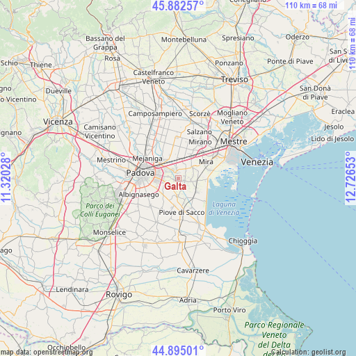
Galta GPS coordinates[2]
45° 23' 27.42" North, 12° 1' 24.24" East
| Map corner | latitude | longitude |
|---|---|---|
| Upper-left | 45.88257°, | 11.32028° |
| Center: | 45.39095°, | 12.0234° |
| Lower-right: | 44.89501°, | 12.72653° |
| Map W x H: | 109.8×109.8 km | = 68.2×68.2mi |
| max Lat: | 47.04031° ⇑30% North |
| Galta: | 45.39095° |
| min Lat: | ⇓70% South 35.50142° |
| min Long | Galta | max Long |
| 6.69888° | 12.0234° | 18.48682° |
| W 56.2%⇐ | ⇒43.8% E |
Elevation
Elevation of Galta is 4 m = 13 ft, and this is 302.7 m = 993 ft below average elevation for this country.
| Max E: |
2085 m = 6841 ft | 97.8% |
| Avg. | 306.7 m = 1006 ft | |
| Galta | 4 m = 13 ft | |
Min E: |
-4 m = -13 ft | 2.2% |
See also: Italy elevation on elevation.city.
Geographical zone
Galta is located in North temperate zone (between Tropic of Cancer and the Arctic Circle). Distance of this North polar circle is 2354.2 km =1462.8 mi to North.| Distance of | km | miles | from Galta |
|---|---|---|---|
| North Pole | 4960.1 | 3082.1 | to North |
| Arctic Circle | 2354.2 | 1462.8 | to North |
| Tropic Cancer | 2441.1 | 1516.8 | to South |
| Equator | 5047 | 3136.1 | to South |


Nearby cities:
15 places around Galta: (largest is in red/bold)
• Arino
5.8 km =3.6 mi,  24°
24°
• Brigo-Paluello
3.1 km =1.9 mi,  44°
44°
• Campolongo Maggiore Liettoli
5.7 km =3.5 mi,  179°
179°
• Camponogara
5.1 km =3.2 mi,  104°
104°
• Fiesso
3.3 km =2.1 mi,  14°
14°
• Fiesso d'Artico
3.4 km =2.1 mi, 7°
• Fossò
1.9 km =1.2 mi,  107°
107°
• Oltre Brenta
3.1 km =1.9 mi,  319°
319°
• San Vito
5.7 km =3.5 mi,  302°
302°
• Sandon
3.4 km =2.1 mi,  153°
153°
• Saonara
4.2 km =2.6 mi,  226°
226°
• Stra
2.4 km =1.5 mi,  342°
342°
• Tombelle
3.3 km =2.1 mi,  284°
284°
• Vigonovo
1.4 km =0.9 mi,  251°
251°
• Villatora
4.4 km =2.7 mi,  265°
265°
Sources, notices
• [Note1] Compared only with cities in Italy existing in our database
• [Src1] Map data: © OpenStreetMap contributors (CC-BY-SA)
• [Src2] Other city data from geonames.org with taken over terms of usage.
• [Src3] Geographical zone / Annual Mean Temperature by Robert A. Rohde @ Wikipedia
