Saonara geodata
Saonara (Veneto) is a seat of a third-order administrative division; located in Italy in Europe/Rome (GMT+2) time zone. With population of 1,963 people, there are 4225 cities with bigger population in this country. Compared to other cities in Italy, 69.3% of cities are located further ↓South; 55.7% of cities are located further ←West and 97.2% of cities have higher elevation than Saonara. Note1


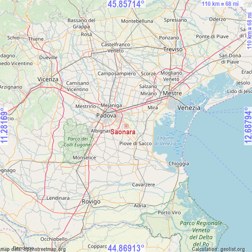
Saonara GPS coordinates[2]
45° 21' 55.044" North, 11° 59' 5.316" East
| Map corner | latitude | longitude |
|---|---|---|
| Upper-left | 45.85714°, | 11.28169° |
| Center: | 45.36529°, | 11.98481° |
| Lower-right: | 44.86913°, | 12.68794° |
| Map W x H: | 109.9×109.9 km | = 68.3×68.3mi |
| max Lat: | 47.04031° ⇑30.7% North |
| Saonara: | 45.36529° |
| min Lat: | ⇓69.3% South 35.50142° |
| min Long | Saonara | max Long |
| 6.69888° | 11.98481° | 18.48682° |
| W 55.7%⇐ | ⇒44.3% E |
Elevation
Elevation of Saonara is 5 m = 16 ft, and this is 301.7 m = 990 ft below average elevation for this country.
| Max E: |
2085 m = 6841 ft | 97.2% |
| Avg. | 306.7 m = 1006 ft | |
| Saonara | 5 m = 16 ft | |
Min E: |
-4 m = -13 ft | 2.8% |
See also: Italy elevation on elevation.city.
Geographical zone
Saonara is located in North temperate zone (between Tropic of Cancer and the Arctic Circle). Distance of this North polar circle is 2357 km =1464.6 mi to North.| Distance of | km | miles | from Saonara |
|---|---|---|---|
| North Pole | 4962.9 | 3083.8 | to North |
| Arctic Circle | 2357 | 1464.6 | to North |
| Tropic Cancer | 2438.2 | 1515 | to South |
| Equator | 5044.1 | 3134.3 | to South |


Nearby cities:
15 places around Saonara: (largest is in red/bold)
• Campolongo Maggiore Liettoli
4.2 km =2.6 mi,  133°
133°
• Fossò
5.3 km =3.3 mi,  64°
64°
• Galta
4.2 km =2.6 mi,  46°
46°
• Legnaro
3 km =1.9 mi,  211°
211°
• Noventa
6.1 km =3.8 mi,  334°
334°
• Oltre Brenta
5.3 km =3.3 mi,  11°
11°
• Ponte San Nicolò
4.8 km =3 mi,  272°
272°
• Roncajette
4.3 km =2.7 mi,  238°
238°
• San Vito
6.2 km =3.9 mi,  343°
343°
• Sandon
4.5 km =2.8 mi,  92°
92°
• Sant'Angelo di Piove di Sacco
5.7 km =3.5 mi,  160°
160°
• Stra
5.6 km =3.5 mi,  24°
24°
• Tombelle
3.7 km =2.3 mi,  356°
356°
• Vigonovo
2.9 km =1.8 mi,  35°
35°
• Villatora
2.8 km =1.7 mi, 331°
Sources, notices
• [Note1] Compared only with cities in Italy existing in our database
• [Src1] Map data: © OpenStreetMap contributors (CC-BY-SA)
• [Src2] Other city data from geonames.org with taken over terms of usage.
• [Src3] Geographical zone / Annual Mean Temperature by Robert A. Rohde @ Wikipedia
