Figino geodata
Figino (Lombardy) is a populated place; located in Italy in Europe/Rome (GMT+2) time zone. With population of 1,580 people, there are 4945 cities with bigger population in this country. Compared to other cities in Italy, 73.4% of cities are located further ↓South; 80.1% of cities are located further →East and 63.5% of cities have higher elevation than Figino. Note1
Administrative division(s):
- Level 1: Lombardy
- Level 2: Città metropolitana di Milano
- Level 3: Milano
- Level 4: Municipio 7


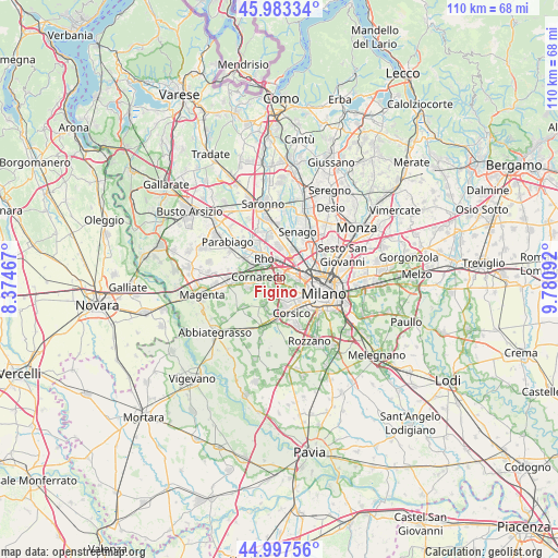
Figino GPS coordinates[2]
45° 29' 33.396" North, 9° 4' 40.044" East
| Map corner | latitude | longitude |
|---|---|---|
| Upper-left | 45.98334°, | 8.37467° |
| Center: | 45.49261°, | 9.07779° |
| Lower-right: | 44.99756°, | 9.78092° |
| Map W x H: | 109.6×109.6 km | = 68.1×68.1mi |
| max Lat: | 47.04031° ⇑26.6% North |
| Figino: | 45.49261° |
| min Lat: | ⇓73.4% South 35.50142° |
| min Long | Figino | max Long |
| 6.69888° | 9.07779° | 18.48682° |
| W 19.9%⇐ | ⇒80.1% E |
Elevation
Elevation of Figino is 137 m = 449 ft, and this is 169.7 m = 557 ft below average elevation for this country.
| Max E: |
2085 m = 6841 ft | 63.5% |
| Avg. | 306.7 m = 1006 ft | |
| Figino | 137 m = 449 ft | |
Min E: |
-4 m = -13 ft | 36.5% |
See also: Italy elevation on elevation.city.
Geographical zone
Figino is located in North temperate zone (between Tropic of Cancer and the Arctic Circle). Distance of this North polar circle is 2342.9 km =1455.8 mi to North.| Distance of | km | miles | from Figino |
|---|---|---|---|
| North Pole | 4948.8 | 3075 | to North |
| Arctic Circle | 2342.9 | 1455.8 | to North |
| Tropic Cancer | 2452.4 | 1523.9 | to South |
| Equator | 5058.3 | 3143.1 | to South |


Nearby cities:
15 places around Figino: (largest is in red/bold)
• Arese
6.4 km =4 mi,  359°
359°
• Baranzate
4.9 km =3 mi,  38°
38°
• Bareggio
6.4 km =4 mi,  256°
256°
• Bollate
6.9 km =4.3 mi,  29°
29°
• Cesano Boscone
5.8 km =3.6 mi,  166°
166°
• Cornaredo
4.1 km =2.5 mi,  283°
283°
• Cusago
5.7 km =3.5 mi,  213°
213°
• Monzoro
4.6 km =2.9 mi,  216°
216°
• Novate Milanese
6.4 km =4 mi,  48°
48°
• Passirana
6.7 km =4.2 mi,  336°
336°
• Pero
2.1 km =1.3 mi,  20°
20°
• Pregnana Milanese
6.1 km =3.8 mi,  295°
295°
• Rho
5.3 km =3.3 mi,  326°
326°
• Settimo Milanese
2.4 km =1.5 mi,  226°
226°
• Vighignolo
2.7 km =1.7 mi, 276°
Sources, notices
• [Note1] Compared only with cities in Italy existing in our database
• [Src1] Map data: © OpenStreetMap contributors (CC-BY-SA)
• [Src2] Other city data from geonames.org with taken over terms of usage.
• [Src3] Geographical zone / Annual Mean Temperature by Robert A. Rohde @ Wikipedia
