Vighignolo geodata
Vighignolo (Lombardy) is a populated place; located in Italy in Europe/Rome (GMT+2) time zone. With population of 4,134 people, there are 2322 cities with bigger population in this country. Compared to other cities in Italy, 73.5% of cities are located further ↓South; 80.6% of cities are located further →East and 62.8% of cities have higher elevation than Vighignolo. Note1
Administrative division(s):
- Level 1: Lombardy
- Level 2: Città metropolitana di Milano
- Level 3: Settimo Milanese


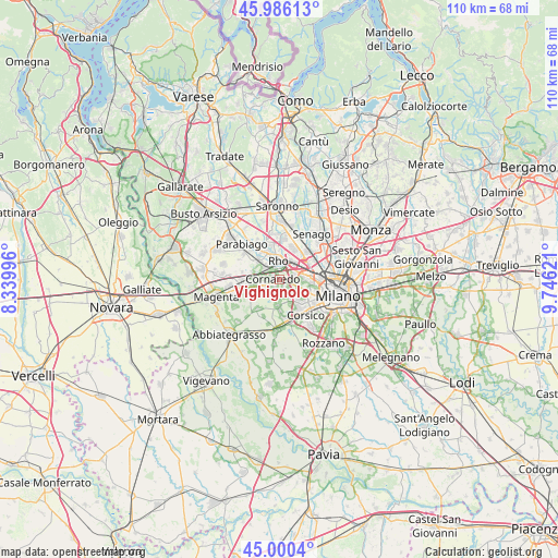
Vighignolo GPS coordinates[2]
45° 29' 43.512" North, 9° 2' 35.088" East
| Map corner | latitude | longitude |
|---|---|---|
| Upper-left | 45.98613°, | 8.33996° |
| Center: | 45.49542°, | 9.04308° |
| Lower-right: | 45.0004°, | 9.74621° |
| Map W x H: | 109.6×109.6 km | = 68.1×68.1mi |
| max Lat: | 47.04031° ⇑26.5% North |
| Vighignolo: | 45.49542° |
| min Lat: | ⇓73.5% South 35.50142° |
| min Long | Vighignolo | max Long |
| 6.69888° | 9.04308° | 18.48682° |
| W 19.4%⇐ | ⇒80.6% E |
Elevation
Elevation of Vighignolo is 143 m = 469 ft, and this is 163.7 m = 537 ft below average elevation for this country.
| Max E: |
2085 m = 6841 ft | 62.8% |
| Avg. | 306.7 m = 1006 ft | |
| Vighignolo | 143 m = 469 ft | |
Min E: |
-4 m = -13 ft | 37.2% |
See also: Italy elevation on elevation.city.
Geographical zone
Vighignolo is located in North temperate zone (between Tropic of Cancer and the Arctic Circle). Distance of this North polar circle is 2342.6 km =1455.6 mi to North.| Distance of | km | miles | from Vighignolo |
|---|---|---|---|
| North Pole | 4948.4 | 3074.8 | to North |
| Arctic Circle | 2342.6 | 1455.6 | to North |
| Tropic Cancer | 2452.7 | 1524 | to South |
| Equator | 5058.6 | 3143.3 | to South |


Nearby cities:
15 places around Vighignolo: (largest is in red/bold)
• Bareggio
4 km =2.5 mi,  242°
242°
• Cornaredo
1.4 km =0.9 mi,  297°
297°
• Cusago
5.1 km =3.2 mi,  184°
184°
• Figino
2.7 km =1.7 mi,  96°
96°
• Mantegazza
5.7 km =3.5 mi,  285°
285°
• Monzoro
4 km =2.5 mi, 180°
• Passirana
5.8 km =3.6 mi,  0°
0°
• Pero
3.8 km =2.4 mi,  64°
64°
• Pogliano Milanese
6.1 km =3.8 mi,  320°
320°
• Pregnana Milanese
3.6 km =2.2 mi,  309°
309°
• Rho
4.1 km =2.5 mi,  356°
356°
• Rogorotto
5.9 km =3.7 mi,  281°
281°
• Sedriano
5.6 km =3.5 mi,  265°
265°
• Settimo Milanese
2.2 km =1.4 mi,  153°
153°
• Vanzago
5.3 km =3.3 mi, 309°
Sources, notices
• [Note1] Compared only with cities in Italy existing in our database
• [Src1] Map data: © OpenStreetMap contributors (CC-BY-SA)
• [Src2] Other city data from geonames.org with taken over terms of usage.
• [Src3] Geographical zone / Annual Mean Temperature by Robert A. Rohde @ Wikipedia
