Mantegazza geodata
Mantegazza (Lombardy) is a populated place; located in Italy in Europe/Rome (GMT+2) time zone. With population of 1,479 people, there are 5168 cities with bigger population in this country. Compared to other cities in Italy, 74% of cities are located further ↓South; 81.6% of cities are located further →East and 60.8% of cities have higher elevation than Mantegazza. Note1
Administrative division(s):
- Level 1: Lombardy
- Level 2: Città metropolitana di Milano
- Level 3: Vanzago


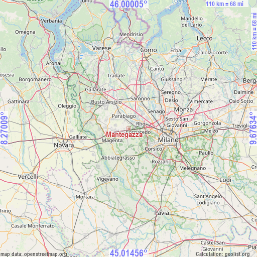
Mantegazza GPS coordinates[2]
45° 30' 34.056" North, 8° 58' 23.556" East
| Map corner | latitude | longitude |
|---|---|---|
| Upper-left | 46.00005°, | 8.27009° |
| Center: | 45.50946°, | 8.97321° |
| Lower-right: | 45.01456°, | 9.67634° |
| Map W x H: | 109.6×109.6 km | = 68.1×68.1mi |
| max Lat: | 47.04031° ⇑26% North |
| Mantegazza: | 45.50946° |
| min Lat: | ⇓74% South 35.50142° |
| min Long | Mantegazza | max Long |
| 6.69888° | 8.97321° | 18.48682° |
| W 18.4%⇐ | ⇒81.6% E |
Elevation
Elevation of Mantegazza is 157 m = 515 ft, and this is 149.7 m = 491 ft below average elevation for this country.
| Max E: |
2085 m = 6841 ft | 60.8% |
| Avg. | 306.7 m = 1006 ft | |
| Mantegazza | 157 m = 515 ft | |
Min E: |
-4 m = -13 ft | 39.2% |
See also: Italy elevation on elevation.city.
Geographical zone
Mantegazza is located in North temperate zone (between Tropic of Cancer and the Arctic Circle). Distance of this North polar circle is 2341 km =1454.6 mi to North.| Distance of | km | miles | from Mantegazza |
|---|---|---|---|
| North Pole | 4946.9 | 3073.9 | to North |
| Arctic Circle | 2341 | 1454.6 | to North |
| Tropic Cancer | 2454.3 | 1525 | to South |
| Equator | 5060.2 | 3144.3 | to South |


Nearby cities:
15 places around Mantegazza: (largest is in red/bold)
• Arluno
2.5 km =1.6 mi,  254°
254°
• Bareggio
3.9 km =2.4 mi,  150°
150°
• Casorezzo
5.7 km =3.5 mi,  284°
284°
• Castellazzo
4.6 km =2.9 mi,  209°
209°
• Cornaredo
4.3 km =2.7 mi,  102°
102°
• Nerviano
4.9 km =3 mi,  5°
5°
• Pogliano Milanese
3.5 km =2.2 mi,  27°
27°
• Pregnana Milanese
2.7 km =1.7 mi,  74°
74°
• Rho
5.8 km =3.6 mi,  63°
63°
• Rogorotto
0.5 km =0.3 mi,  219°
219°
• Santo Stefano Ticino
5.2 km =3.2 mi,  240°
240°
• Sedriano
2.1 km =1.3 mi,  183°
183°
• Vanzago
2.3 km =1.4 mi,  37°
37°
• Vighignolo
5.7 km =3.5 mi,  105°
105°
• Vittuone
2.9 km =1.8 mi, 215°
Sources, notices
• [Note1] Compared only with cities in Italy existing in our database
• [Src1] Map data: © OpenStreetMap contributors (CC-BY-SA)
• [Src2] Other city data from geonames.org with taken over terms of usage.
• [Src3] Geographical zone / Annual Mean Temperature by Robert A. Rohde @ Wikipedia
