Pievedizio geodata
Pievedizio (Lombardy) is a populated place; located in Italy in Europe/Rome (GMT+2) time zone. With population of 1,244 people, there are 5812 cities with bigger population in this country. Compared to other cities in Italy, 72.2% of cities are located further ↓South; 67% of cities are located further →East and 69.6% of cities have higher elevation than Pievedizio. Note1


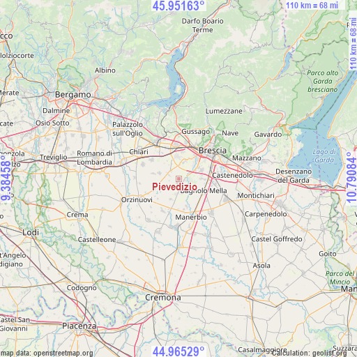
Pievedizio GPS coordinates[2]
45° 27' 38.232" North, 10° 5' 15.756" East
| Map corner | latitude | longitude |
|---|---|---|
| Upper-left | 45.95163°, | 9.38458° |
| Center: | 45.46062°, | 10.08771° |
| Lower-right: | 44.96529°, | 10.79084° |
| Map W x H: | 109.7×109.7 km | = 68.2×68.2mi |
| max Lat: | 47.04031° ⇑27.8% North |
| Pievedizio: | 45.46062° |
| min Lat: | ⇓72.2% South 35.50142° |
| min Long | Pievedizio | max Long |
| 6.69888° | 10.08771° | 18.48682° |
| W 33%⇐ | ⇒67% E |
Elevation
Elevation of Pievedizio is 100 m = 328 ft, and this is 206.7 m = 678 ft below average elevation for this country.
| Max E: |
2085 m = 6841 ft | 69.6% |
| Avg. | 306.7 m = 1006 ft | |
| Pievedizio | 100 m = 328 ft | |
Min E: |
-4 m = -13 ft | 30.4% |
See also: Italy elevation on elevation.city.
Geographical zone
Pievedizio is located in North temperate zone (between Tropic of Cancer and the Arctic Circle). Distance of this North polar circle is 2346.4 km =1458 mi to North.| Distance of | km | miles | from Pievedizio |
|---|---|---|---|
| North Pole | 4952.3 | 3077.2 | to North |
| Arctic Circle | 2346.4 | 1458 | to North |
| Tropic Cancer | 2448.8 | 1521.6 | to South |
| Equator | 5054.7 | 3140.8 | to South |


Nearby cities:
15 places around Pievedizio: (largest is in red/bold)
• Azzano Mella
2.4 km =1.5 mi,  106°
106°
• Bargnano
5.1 km =3.2 mi,  229°
229°
• Berlingo
6.3 km =3.9 mi,  318°
318°
• Brandico
2.8 km =1.7 mi,  255°
255°
• Capriano del Colle
3.8 km =2.4 mi,  65°
65°
• Castel Mella
6.2 km =3.9 mi,  46°
46°
• Corticelle Pieve
4.8 km =3 mi,  148°
148°
• Dello
4.7 km =2.9 mi,  191°
191°
• Lograto
3.6 km =2.2 mi, 317°
• Longhena
3.4 km =2.1 mi,  220°
220°
• Maclodio
4 km =2.5 mi,  298°
298°
• Mairano
1.5 km =0.9 mi,  203°
203°
• Quinzanello
4.7 km =2.9 mi,  170°
170°
• Torbole Casaglia
6.2 km =3.9 mi,  21°
21°
• Trenzano
6.3 km =3.9 mi,  287°
287°
Sources, notices
• [Note1] Compared only with cities in Italy existing in our database
• [Src1] Map data: © OpenStreetMap contributors (CC-BY-SA)
• [Src2] Other city data from geonames.org with taken over terms of usage.
• [Src3] Geographical zone / Annual Mean Temperature by Robert A. Rohde @ Wikipedia
