Maclodio geodata
Maclodio (Lombardy) is a seat of a third-order administrative division; located in Italy in Europe/Rome (GMT+2) time zone. With population of 1,378 people, there are 5413 cities with bigger population in this country. Compared to other cities in Italy, 72.8% of cities are located further ↓South; 67.4% of cities are located further →East and 68.3% of cities have higher elevation than Maclodio. Note1


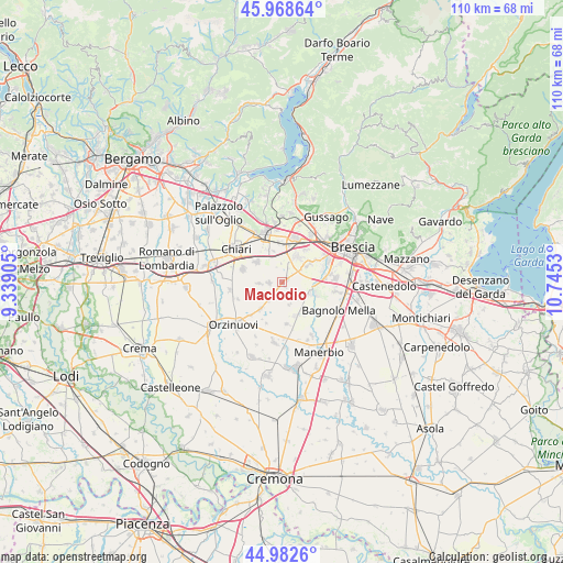
Maclodio GPS coordinates[2]
45° 28' 40.008" North, 10° 2' 31.812" East
| Map corner | latitude | longitude |
|---|---|---|
| Upper-left | 45.96864°, | 9.33905° |
| Center: | 45.47778°, | 10.04217° |
| Lower-right: | 44.9826°, | 10.7453° |
| Map W x H: | 109.6×109.6 km | = 68.1×68.1mi |
| max Lat: | 47.04031° ⇑27.2% North |
| Maclodio: | 45.47778° |
| min Lat: | ⇓72.8% South 35.50142° |
| min Long | Maclodio | max Long |
| 6.69888° | 10.04217° | 18.48682° |
| W 32.6%⇐ | ⇒67.4% E |
Elevation
Elevation of Maclodio is 107 m = 351 ft, and this is 199.7 m = 655 ft below average elevation for this country.
| Max E: |
2085 m = 6841 ft | 68.3% |
| Avg. | 306.7 m = 1006 ft | |
| Maclodio | 107 m = 351 ft | |
Min E: |
-4 m = -13 ft | 31.7% |
See also: Italy elevation on elevation.city.
Geographical zone
Maclodio is located in North temperate zone (between Tropic of Cancer and the Arctic Circle). Distance of this North polar circle is 2344.5 km =1456.8 mi to North.| Distance of | km | miles | from Maclodio |
|---|---|---|---|
| North Pole | 4950.4 | 3076 | to North |
| Arctic Circle | 2344.5 | 1456.8 | to North |
| Tropic Cancer | 2450.7 | 1522.8 | to South |
| Equator | 5056.7 | 3142.1 | to South |


Nearby cities:
15 places around Maclodio: (largest is in red/bold)
• Azzano Mella
6.4 km =4 mi,  113°
113°
• Bargnano
5.2 km =3.2 mi,  183°
183°
• Berlinghetto
3.7 km =2.3 mi,  358°
358°
• Berlingo
2.8 km =1.7 mi,  347°
347°
• Brandico
2.7 km =1.7 mi,  162°
162°
• Castrezzato
6.1 km =3.8 mi,  307°
307°
• Corzano
4.7 km =2.9 mi,  215°
215°
• Duomo
6.3 km =3.9 mi,  344°
344°
• Lograto
1.4 km =0.9 mi,  56°
56°
• Longhena
4.7 km =2.9 mi, 162°
• Mairano
4.4 km =2.7 mi,  138°
138°
• Pievedizio
4 km =2.5 mi,  118°
118°
• Pompiano
6.6 km =4.1 mi, 218°
• Travagliato
5.9 km =3.7 mi,  29°
29°
• Trenzano
2.5 km =1.6 mi,  268°
268°
Sources, notices
• [Note1] Compared only with cities in Italy existing in our database
• [Src1] Map data: © OpenStreetMap contributors (CC-BY-SA)
• [Src2] Other city data from geonames.org with taken over terms of usage.
• [Src3] Geographical zone / Annual Mean Temperature by Robert A. Rohde @ Wikipedia
