Lograto geodata
Lograto (Lombardy) is a seat of a third-order administrative division; located in Italy in Europe/Rome (GMT+2) time zone. With population of 3,333 people, there are 2816 cities with bigger population in this country. Compared to other cities in Italy, 73% of cities are located further ↓South; 67.2% of cities are located further →East and 67.6% of cities have higher elevation than Lograto. Note1


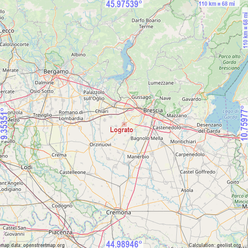
Lograto GPS coordinates[2]
45° 29' 4.488" North, 10° 3' 23.904" East
| Map corner | latitude | longitude |
|---|---|---|
| Upper-left | 45.97539°, | 9.35351° |
| Center: | 45.48458°, | 10.05664° |
| Lower-right: | 44.98946°, | 10.75977° |
| Map W x H: | 109.6×109.6 km | = 68.1×68.1mi |
| max Lat: | 47.04031° ⇑27% North |
| Lograto: | 45.48458° |
| min Lat: | ⇓73% South 35.50142° |
| min Long | Lograto | max Long |
| 6.69888° | 10.05664° | 18.48682° |
| W 32.8%⇐ | ⇒67.2% E |
Elevation
Elevation of Lograto is 111 m = 364 ft, and this is 195.7 m = 642 ft below average elevation for this country.
| Max E: |
2085 m = 6841 ft | 67.6% |
| Avg. | 306.7 m = 1006 ft | |
| Lograto | 111 m = 364 ft | |
Min E: |
-4 m = -13 ft | 32.4% |
See also: Italy elevation on elevation.city.
Geographical zone
Lograto is located in North temperate zone (between Tropic of Cancer and the Arctic Circle). Distance of this North polar circle is 2343.8 km =1456.4 mi to North.| Distance of | km | miles | from Lograto |
|---|---|---|---|
| North Pole | 4949.7 | 3075.6 | to North |
| Arctic Circle | 2343.8 | 1456.4 | to North |
| Tropic Cancer | 2451.5 | 1523.3 | to South |
| Equator | 5057.4 | 3142.5 | to South |


Nearby cities:
15 places around Lograto: (largest is in red/bold)
• Azzano Mella
5.8 km =3.6 mi,  125°
125°
• Bargnano
6.1 km =3.8 mi,  193°
193°
• Berlinghetto
3.1 km =1.9 mi,  337°
337°
• Berlingo
2.7 km =1.7 mi,  319°
319°
• Brandico
3.4 km =2.1 mi, 185°
• Capriano del Colle
6 km =3.7 mi,  100°
100°
• Corzano
5.9 km =3.7 mi,  220°
220°
• Duomo
6 km =3.7 mi,  332°
332°
• Longhena
5.2 km =3.2 mi,  177°
177°
• Maclodio
1.4 km =0.9 mi,  236°
236°
• Mairano
4.4 km =2.7 mi,  156°
156°
• Pievedizio
3.6 km =2.2 mi,  137°
137°
• Torbole Casaglia
5.7 km =3.5 mi,  56°
56°
• Travagliato
4.7 km =2.9 mi,  22°
22°
• Trenzano
3.7 km =2.3 mi,  257°
257°
Sources, notices
• [Note1] Compared only with cities in Italy existing in our database
• [Src1] Map data: © OpenStreetMap contributors (CC-BY-SA)
• [Src2] Other city data from geonames.org with taken over terms of usage.
• [Src3] Geographical zone / Annual Mean Temperature by Robert A. Rohde @ Wikipedia
