Bevagna geodata
Bevagna (Umbria) is a seat of a third-order administrative division; located in Italy in Europe/Rome (GMT+2) time zone. With population of 2,705 people, there are 3298 cities with bigger population in this country. Compared to other cities in Italy, 63.7% of cities are located further ↑North; 63.8% of cities are located further ←West and 52.3% of cities have higher elevation than Bevagna. Note1


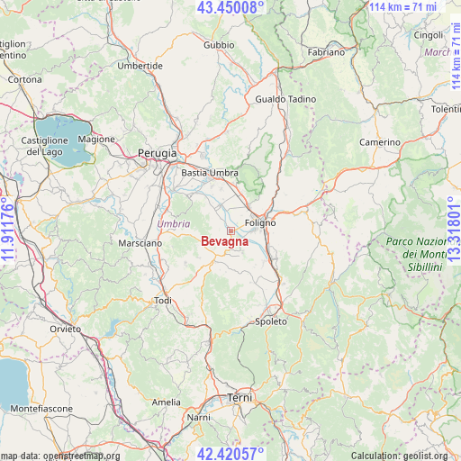
Bevagna GPS coordinates[2]
42° 56' 14.928" North, 12° 36' 53.568" East
| Map corner | latitude | longitude |
|---|---|---|
| Upper-left | 43.45008°, | 11.91176° |
| Center: | 42.93748°, | 12.61488° |
| Lower-right: | 42.42057°, | 13.31801° |
| Map W x H: | 114.5×114.5 km | = 71.1×71.1mi |
| max Lat: | 47.04031° ⇑63.7% North |
| Bevagna: | 42.93748° |
| min Lat: | ⇓36.3% South 35.50142° |
| min Long | Bevagna | max Long |
| 6.69888° | 12.61488° | 18.48682° |
| W 63.8%⇐ | ⇒36.2% E |
Elevation
Elevation of Bevagna is 220 m = 722 ft, and this is 86.7 m = 284 ft below average elevation for this country.
| Max E: |
2085 m = 6841 ft | 52.3% |
| Avg. | 306.7 m = 1006 ft | |
| Bevagna | 220 m = 722 ft | |
Min E: |
-4 m = -13 ft | 47.7% |
See also: Italy elevation on elevation.city.
Geographical zone
Bevagna is located in North temperate zone (between Tropic of Cancer and the Arctic Circle). Distance of this Northern Tropic circle is 2168.3 km =1347.3 mi to South.| Distance of | km | miles | from Bevagna |
|---|---|---|---|
| North Pole | 5232.9 | 3251.6 | to North |
| Arctic Circle | 2627 | 1632.3 | to North |
| Tropic Cancer | 2168.3 | 1347.3 | to South |
| Equator | 4774.2 | 2966.5 | to South |


Nearby cities:
15 places around Bevagna: (largest is in red/bold)
• Bastardo
8.6 km =5.3 mi,  211°
211°
• Cannaiola
11.4 km =7.1 mi,  135°
135°
• Cannara
7 km =4.3 mi,  337°
337°
• Capitan Loreto
9.3 km =5.8 mi,  16°
16°
• Case Nuove
10 km =6.2 mi,  12°
12°
• Castelnuovo
10.5 km =6.5 mi,  346°
346°
• Fiamenga
4.2 km =2.6 mi,  63°
63°
• Foligno
7.4 km =4.6 mi,  74°
74°
• Giano dell'Umbria
11.9 km =7.4 mi,  194°
194°
• Gualdo Cattaneo
5.5 km =3.4 mi,  239°
239°
• Maceratola
4.8 km =3 mi, 73°
• Marcellano
10.7 km =6.6 mi,  228°
228°
• Montefalco
5.9 km =3.7 mi,  152°
152°
• Rivotorto
11.9 km =7.4 mi,  2°
2°
• Spello
7.4 km =4.6 mi,  34°
34°
Sources, notices
• [Note1] Compared only with cities in Italy existing in our database
• [Src1] Map data: © OpenStreetMap contributors (CC-BY-SA)
• [Src2] Other city data from geonames.org with taken over terms of usage.
• [Src3] Geographical zone / Annual Mean Temperature by Robert A. Rohde @ Wikipedia
