Fiamenga geodata
Fiamenga (Umbria) is a populated place; located in Italy in Europe/Rome (GMT+2) time zone. With population of 558 people, there are 9366 cities with bigger population in this country. Compared to other cities in Italy, 63.6% of cities are located further ↑North; 64.5% of cities are located further ←West and 53.6% of cities have higher elevation than Fiamenga. Note1


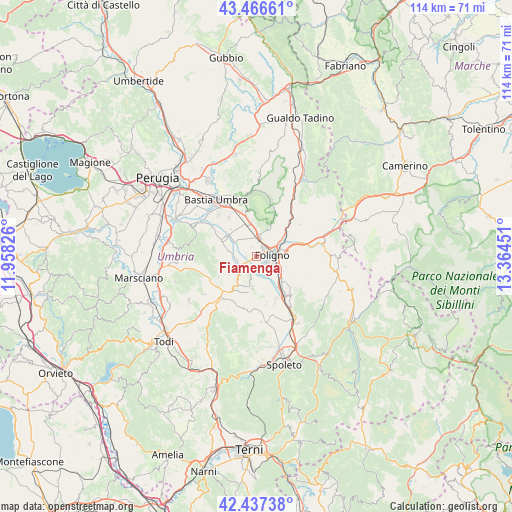
Fiamenga GPS coordinates[2]
42° 57' 14.94" North, 12° 39' 40.968" East
| Map corner | latitude | longitude |
|---|---|---|
| Upper-left | 43.46661°, | 11.95826° |
| Center: | 42.95415°, | 12.66138° |
| Lower-right: | 42.43738°, | 13.36451° |
| Map W x H: | 114.4×114.4 km | = 71.1×71.1mi |
| max Lat: | 47.04031° ⇑63.6% North |
| Fiamenga: | 42.95415° |
| min Lat: | ⇓36.4% South 35.50142° |
| min Long | Fiamenga | max Long |
| 6.69888° | 12.66138° | 18.48682° |
| W 64.5%⇐ | ⇒35.5% E |
Elevation
Elevation of Fiamenga is 213 m = 699 ft, and this is 93.7 m = 307 ft below average elevation for this country.
| Max E: |
2085 m = 6841 ft | 53.6% |
| Avg. | 306.7 m = 1006 ft | |
| Fiamenga | 213 m = 699 ft | |
Min E: |
-4 m = -13 ft | 46.4% |
See also: Italy elevation on elevation.city.
Geographical zone
Fiamenga is located in North temperate zone (between Tropic of Cancer and the Arctic Circle). Distance of this Northern Tropic circle is 2170.1 km =1348.4 mi to South.| Distance of | km | miles | from Fiamenga |
|---|---|---|---|
| North Pole | 5231 | 3250.4 | to North |
| Arctic Circle | 2625.1 | 1631.2 | to North |
| Tropic Cancer | 2170.1 | 1348.4 | to South |
| Equator | 4776.1 | 2967.7 | to South |


Nearby cities:
15 places around Fiamenga: (largest is in red/bold)
• Bevagna
4.2 km =2.6 mi,  243°
243°
• Cannaiola
10.8 km =6.7 mi,  156°
156°
• Cannara
7.9 km =4.9 mi,  305°
305°
• Capitan Loreto
7.1 km =4.4 mi,  350°
350°
• Case Nuove
8.1 km =5 mi, 348°
• Castelnuovo
10.5 km =6.5 mi,  323°
323°
• Foligno
3.4 km =2.1 mi,  88°
88°
• Gualdo Cattaneo
9.7 km =6 mi, 241°
• Maceratola
0.9 km =0.6 mi,  121°
121°
• Montefalco
7.1 km =4.4 mi,  188°
188°
• Rivotorto
10.5 km =6.5 mi,  341°
341°
• San Vitale
10.4 km =6.5 mi, 349°
• Santa Maria in Valle
9.9 km =6.2 mi,  133°
133°
• Spello
4.3 km =2.7 mi,  5°
5°
• Trevi
11.1 km =6.9 mi,  139°
139°
Sources, notices
• [Note1] Compared only with cities in Italy existing in our database
• [Src1] Map data: © OpenStreetMap contributors (CC-BY-SA)
• [Src2] Other city data from geonames.org with taken over terms of usage.
• [Src3] Geographical zone / Annual Mean Temperature by Robert A. Rohde @ Wikipedia
