Pizzoletta geodata
Pizzoletta (Veneto) is a populated place; located in Italy in Europe/Rome (GMT+2) time zone. With population of 887 people, there are 7229 cities with bigger population in this country. Compared to other cities in Italy, 68.2% of cities are located further ↓South; 59.4% of cities are located further →East and 80.3% of cities have higher elevation than Pizzoletta. Note1
Administrative division(s):
- Level 1: Veneto
- Level 2: Provincia di Verona
- Level 3: Villafranca di Verona


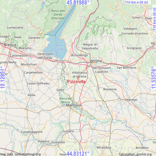
Pizzoletta GPS coordinates[2]
45° 19' 39.72" North, 10° 49' 57.468" East
| Map corner | latitude | longitude |
|---|---|---|
| Upper-left | 45.81988°, | 10.12951° |
| Center: | 45.3277°, | 10.83263° |
| Lower-right: | 44.83121°, | 11.53576° |
| Map W x H: | 109.9×109.9 km | = 68.3×68.3mi |
| max Lat: | 47.04031° ⇑31.8% North |
| Pizzoletta: | 45.3277° |
| min Lat: | ⇓68.2% South 35.50142° |
| min Long | Pizzoletta | max Long |
| 6.69888° | 10.83263° | 18.48682° |
| W 40.6%⇐ | ⇒59.4% E |
Elevation
Elevation of Pizzoletta is 48 m = 157 ft, and this is 258.7 m = 849 ft below average elevation for this country.
| Max E: |
2085 m = 6841 ft | 80.3% |
| Avg. | 306.7 m = 1006 ft | |
| Pizzoletta | 48 m = 157 ft | |
Min E: |
-4 m = -13 ft | 19.7% |
See also: Italy elevation on elevation.city.
Geographical zone
Pizzoletta is located in North temperate zone (between Tropic of Cancer and the Arctic Circle). Distance of this North polar circle is 2361.2 km =1467.2 mi to North.| Distance of | km | miles | from Pizzoletta |
|---|---|---|---|
| North Pole | 4967.1 | 3086.4 | to North |
| Arctic Circle | 2361.2 | 1467.2 | to North |
| Tropic Cancer | 2434 | 1512.4 | to South |
| Equator | 5040 | 3131.7 | to South |


Nearby cities:
15 places around Pizzoletta: (largest is in red/bold)
• Bagnolo
7.7 km =4.8 mi,  143°
143°
• Caluri
6.8 km =4.2 mi,  31°
31°
• Castiglione Mantovano
7.4 km =4.6 mi,  196°
196°
• Custoza
6.2 km =3.9 mi,  332°
332°
• Grezzano
2.4 km =1.5 mi,  120°
120°
• Isolalta
7.1 km =4.4 mi,  81°
81°
• Malavicina
4.8 km =3 mi,  228°
228°
• Mozzecane
2.6 km =1.6 mi,  210°
210°
• Nogarole Rocca
5.8 km =3.6 mi, 136°
• Povegliano Veronese
4.3 km =2.7 mi,  59°
59°
• Pradelle
5.8 km =3.6 mi,  148°
148°
• Quaderni
3.4 km =2.1 mi,  272°
272°
• Rosegaferro
2.6 km =1.6 mi,  313°
313°
• San Zeno
1 km =0.6 mi, 196°
• Villafranca di Verona
3.1 km =1.9 mi,  17°
17°
Sources, notices
• [Note1] Compared only with cities in Italy existing in our database
• [Src1] Map data: © OpenStreetMap contributors (CC-BY-SA)
• [Src2] Other city data from geonames.org with taken over terms of usage.
• [Src3] Geographical zone / Annual Mean Temperature by Robert A. Rohde @ Wikipedia
