Isolalta geodata
Isolalta (Veneto) is a populated place; located in Italy in Europe/Rome (GMT+2) time zone. With population of 758 people, there are 7894 cities with bigger population in this country. Compared to other cities in Italy, 68.5% of cities are located further ↓South; 58.2% of cities are located further →East and 82% of cities have higher elevation than Isolalta. Note1


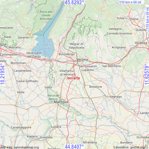
Isolalta GPS coordinates[2]
45° 20' 13.596" North, 10° 55' 21.576" East
| Map corner | latitude | longitude |
|---|---|---|
| Upper-left | 45.8292°, | 10.21954° |
| Center: | 45.33711°, | 10.92266° |
| Lower-right: | 44.8407°, | 11.62579° |
| Map W x H: | 109.9×109.9 km | = 68.3×68.3mi |
| max Lat: | 47.04031° ⇑31.5% North |
| Isolalta: | 45.33711° |
| min Lat: | ⇓68.5% South 35.50142° |
| min Long | Isolalta | max Long |
| 6.69888° | 10.92266° | 18.48682° |
| W 41.8%⇐ | ⇒58.2% E |
Elevation
Elevation of Isolalta is 42 m = 138 ft, and this is 264.7 m = 868 ft below average elevation for this country.
| Max E: |
2085 m = 6841 ft | 82% |
| Avg. | 306.7 m = 1006 ft | |
| Isolalta | 42 m = 138 ft | |
Min E: |
-4 m = -13 ft | 18% |
See also: Italy elevation on elevation.city.
Geographical zone
Isolalta is located in North temperate zone (between Tropic of Cancer and the Arctic Circle). Distance of this North polar circle is 2360.2 km =1466.6 mi to North.| Distance of | km | miles | from Isolalta |
|---|---|---|---|
| North Pole | 4966 | 3085.7 | to North |
| Arctic Circle | 2360.2 | 1466.6 | to North |
| Tropic Cancer | 2435.1 | 1513.1 | to South |
| Equator | 5041 | 3132.3 | to South |


Nearby cities:
15 places around Isolalta: (largest is in red/bold)
• Alpo
4.4 km =2.7 mi,  357°
357°
• Beccacivetta-Azzano
5.1 km =3.2 mi,  36°
36°
• Buttapietra
6 km =3.7 mi,  85°
85°
• Caluri
5.9 km =3.7 mi,  324°
324°
• Dossobuono
6.3 km =3.9 mi,  351°
351°
• Forette
1.8 km =1.1 mi,  71°
71°
• Grezzano
5.5 km =3.4 mi,  245°
245°
• Marchesino-Bovo
6.9 km =4.3 mi,  61°
61°
• Nogarole Rocca
6 km =3.7 mi,  210°
210°
• Pizzoletta
7.1 km =4.4 mi,  261°
261°
• Povegliano Veronese
3.5 km =2.2 mi,  289°
289°
• Pradelle
7.2 km =4.5 mi, 214°
• Trevenzuolo
7.5 km =4.7 mi,  173°
173°
• Vigasio
2.7 km =1.7 mi,  142°
142°
• Villafranca di Verona
6.4 km =4 mi, 287°
Sources, notices
• [Note1] Compared only with cities in Italy existing in our database
• [Src1] Map data: © OpenStreetMap contributors (CC-BY-SA)
• [Src2] Other city data from geonames.org with taken over terms of usage.
• [Src3] Geographical zone / Annual Mean Temperature by Robert A. Rohde @ Wikipedia
