Pradelle geodata
Pradelle (Veneto) is a populated place; located in Italy in Europe/Rome (GMT+2) time zone. With population of 1,143 people, there are 6137 cities with bigger population in this country. Compared to other cities in Italy, 67% of cities are located further ↓South; 58.9% of cities are located further →East and 83.7% of cities have higher elevation than Pradelle. Note1


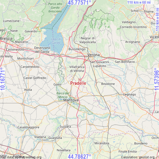
Pradelle GPS coordinates[2]
45° 16' 59.34" North, 10° 52' 14.988" East
| Map corner | latitude | longitude |
|---|---|---|
| Upper-left | 45.77571°, | 10.16771° |
| Center: | 45.28315°, | 10.87083° |
| Lower-right: | 44.78627°, | 11.57396° |
| Map W x H: | 110×110 km | = 68.4×68.4mi |
| max Lat: | 47.04031° ⇑33% North |
| Pradelle: | 45.28315° |
| min Lat: | ⇓67% South 35.50142° |
| min Long | Pradelle | max Long |
| 6.69888° | 10.87083° | 18.48682° |
| W 41.1%⇐ | ⇒58.9% E |
Elevation
Elevation of Pradelle is 35 m = 115 ft, and this is 271.7 m = 891 ft below average elevation for this country.
| Max E: |
2085 m = 6841 ft | 83.7% |
| Avg. | 306.7 m = 1006 ft | |
| Pradelle | 35 m = 115 ft | |
Min E: |
-4 m = -13 ft | 16.3% |
See also: Italy elevation on elevation.city.
Geographical zone
Pradelle is located in North temperate zone (between Tropic of Cancer and the Arctic Circle). Distance of this North polar circle is 2366.2 km =1470.3 mi to North.| Distance of | km | miles | from Pradelle |
|---|---|---|---|
| North Pole | 4972 | 3089.5 | to North |
| Arctic Circle | 2366.2 | 1470.3 | to North |
| Tropic Cancer | 2429.1 | 1509.4 | to South |
| Equator | 5035 | 3128.6 | to South |


Nearby cities:
15 places around Pradelle: (largest is in red/bold)
• Bagnolo
2 km =1.2 mi,  127°
127°
• Castelbelforte
8.1 km =5 mi,  167°
167°
• Castiglione Mantovano
5.5 km =3.4 mi,  247°
247°
• Grezzano
3.9 km =2.4 mi,  346°
346°
• Isolalta
7.2 km =4.5 mi,  34°
34°
• Malavicina
6.8 km =4.2 mi,  285°
285°
• Mozzecane
5.1 km =3.2 mi,  302°
302°
• Nogarole Rocca
1.3 km =0.8 mi,  51°
51°
• Pizzoletta
5.8 km =3.6 mi,  328°
328°
• Povegliano Veronese
7.2 km =4.5 mi,  6°
6°
• Roncolevà
4.8 km =3 mi,  138°
138°
• Roverbella
8.1 km =5 mi,  256°
256°
• San Zeno
5.2 km =3.2 mi,  320°
320°
• Trevenzuolo
5.2 km =3.2 mi,  106°
106°
• Vigasio
6.9 km =4.3 mi,  55°
55°
Sources, notices
• [Note1] Compared only with cities in Italy existing in our database
• [Src1] Map data: © OpenStreetMap contributors (CC-BY-SA)
• [Src2] Other city data from geonames.org with taken over terms of usage.
• [Src3] Geographical zone / Annual Mean Temperature by Robert A. Rohde @ Wikipedia
