Sindacale geodata
Sindacale (Veneto) is a populated place; located in Italy in Europe/Rome (GMT+2) time zone. With population of 704 people, there are 8273 cities with bigger population in this country. Compared to other cities in Italy, 81.3% of cities are located further ↓South; 67% of cities are located further ←West and 100% of cities have higher elevation than Sindacale. Note1
Administrative division(s):
- Level 1: Veneto
- Level 2: Provincia di Venezia
- Level 3: Concordia Sagittaria


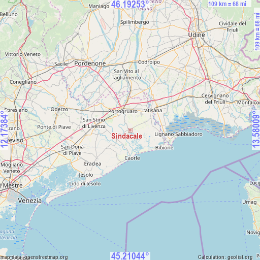
Sindacale GPS coordinates[2]
45° 42' 13.104" North, 12° 52' 37.056" East
| Map corner | latitude | longitude |
|---|---|---|
| Upper-left | 46.19253°, | 12.17384° |
| Center: | 45.70364°, | 12.87696° |
| Lower-right: | 45.21044°, | 13.58009° |
| Map W x H: | 109.2×109.2 km | = 67.9×67.9mi |
| max Lat: | 47.04031° ⇑18.7% North |
| Sindacale: | 45.70364° |
| min Lat: | ⇓81.3% South 35.50142° |
| min Long | Sindacale | max Long |
| 6.69888° | 12.87696° | 18.48682° |
| W 67%⇐ | ⇒33% E |
Elevation
Elevation of Sindacale is -3 m = -10 ft, and this is 309.7 m = 1016 ft below average elevation for this country.
| Max E: |
2085 m = 6841 ft | 100% |
| Avg. | 306.7 m = 1006 ft | |
| Sindacale | -3 m = -10 ft | |
Min E: |
-4 m = -13 ft | 0% |
See also: Italy elevation on elevation.city.
Geographical zone
Sindacale is located in North temperate zone (between Tropic of Cancer and the Arctic Circle). Distance of this North polar circle is 2319.4 km =1441.2 mi to North.| Distance of | km | miles | from Sindacale |
|---|---|---|---|
| North Pole | 4925.3 | 3060.4 | to North |
| Arctic Circle | 2319.4 | 1441.2 | to North |
| Tropic Cancer | 2475.8 | 1538.4 | to South |
| Equator | 5081.8 | 3157.7 | to South |


Nearby cities:
15 places around Sindacale: (largest is in red/bold)
• Caorle
11.9 km =7.4 mi,  180°
180°
• Cesarolo
10.9 km =6.8 mi,  81°
81°
• Concordia Sagittaria
7.6 km =4.7 mi,  327°
327°
• Fossalta di Portogruaro
10.3 km =6.4 mi,  14°
14°
• Gorgo
12.4 km =7.7 mi,  67°
67°
• La Salute di Livenza
8.1 km =5 mi,  226°
226°
• Latisana
12.4 km =7.7 mi,  54°
54°
• Lugugnana
7.2 km =4.5 mi,  63°
63°
• Portogruaro
9 km =5.6 mi,  341°
341°
• San Giorgio al Tagliamento-Pozzi
12.3 km =7.6 mi,  33°
33°
• San Giorgio di Livenza
8.4 km =5.2 mi, 228°
• San Michele al Tagliamento
11.4 km =7.1 mi, 53°
• Stiago
8.1 km =5 mi, 6°
• Summaga
9.9 km =6.2 mi,  321°
321°
• Villanova Santa Margherita
7.2 km =4.5 mi, 11°
Sources, notices
• [Note1] Compared only with cities in Italy existing in our database
• [Src1] Map data: © OpenStreetMap contributors (CC-BY-SA)
• [Src2] Other city data from geonames.org with taken over terms of usage.
• [Src3] Geographical zone / Annual Mean Temperature by Robert A. Rohde @ Wikipedia
