San Giorgio geodata
San Giorgio (Trentino-Alto Adige) is a populated place; located in Italy in Europe/Rome (GMT+2) time zone. With population of 690 people, there are 8364 cities with bigger population in this country. Compared to other cities in Italy, 89.2% of cities are located further ↓South; 59% of cities are located further →East and 74.3% of cities have higher elevation than San Giorgio. Note1
Administrative division(s):
- Level 1: Trentino-Alto Adige
- Level 2: Provincia autonoma di Trento
- Level 3: Arco


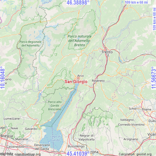
San Giorgio GPS coordinates[2]
45° 54' 6.624" North, 10° 51' 48.96" East
| Map corner | latitude | longitude |
|---|---|---|
| Upper-left | 46.38898°, | 10.16048° |
| Center: | 45.90184°, | 10.8636° |
| Lower-right: | 45.41039°, | 11.56673° |
| Map W x H: | 108.8×108.8 km | = 67.6×67.6mi |
| max Lat: | 47.04031° ⇑10.8% North |
| San Giorgio: | 45.90184° |
| min Lat: | ⇓89.2% South 35.50142° |
| min Long | San Giorgio | max Long |
| 6.69888° | 10.8636° | 18.48682° |
| W 41%⇐ | ⇒59% E |
Elevation
Elevation of San Giorgio is 77 m = 253 ft, and this is 229.7 m = 754 ft below average elevation for this country.
| Max E: |
2085 m = 6841 ft | 74.3% |
| Avg. | 306.7 m = 1006 ft | |
| San Giorgio | 77 m = 253 ft | |
Min E: |
-4 m = -13 ft | 25.7% |
See also: Italy elevation on elevation.city.
Geographical zone
San Giorgio is located in North temperate zone (between Tropic of Cancer and the Arctic Circle). Distance of this North polar circle is 2297.4 km =1427.5 mi to North.| Distance of | km | miles | from San Giorgio |
|---|---|---|---|
| North Pole | 4903.3 | 3046.8 | to North |
| Arctic Circle | 2297.4 | 1427.5 | to North |
| Tropic Cancer | 2497.9 | 1552.1 | to South |
| Equator | 5103.8 | 3171.4 | to South |


Nearby cities:
15 places around San Giorgio: (largest is in red/bold)
• Arco
2.5 km =1.6 mi,  45°
45°
• Bolognano-Vignole
3.4 km =2.1 mi,  70°
70°
• Ceniga
6.2 km =3.9 mi,  28°
28°
• Cologna-Gavazzo Nuova
2.1 km =1.3 mi,  306°
306°
• Concei
10.4 km =6.5 mi,  272°
272°
• Drena
9.8 km =6.1 mi,  40°
40°
• Dro
7.6 km =4.7 mi, 29°
• Molina di Ledro
7.7 km =4.8 mi,  243°
243°
• Mori
10.6 km =6.6 mi,  121°
121°
• Nago-Torbole
3.6 km =2.2 mi,  143°
143°
• Pieve di Ledro
10.3 km =6.4 mi,  261°
261°
• Riva del Garda
2.5 km =1.6 mi,  224°
224°
• Ronzo-Chienis
6.8 km =4.2 mi,  101°
101°
• Tenno
3.2 km =2 mi, 308°
• Torbole sul Garda
3.7 km =2.3 mi,  165°
165°
Sources, notices
• [Note1] Compared only with cities in Italy existing in our database
• [Src1] Map data: © OpenStreetMap contributors (CC-BY-SA)
• [Src2] Other city data from geonames.org with taken over terms of usage.
• [Src3] Geographical zone / Annual Mean Temperature by Robert A. Rohde @ Wikipedia
