Dro geodata
Dro (Trentino-Alto Adige) is a seat of a third-order administrative division; located in Italy in Europe/Rome (GMT+2) time zone. With population of 2,535 people, there are 3489 cities with bigger population in this country. Compared to other cities in Italy, 90.9% of cities are located further ↓South; 58.3% of cities are located further →East and 65.8% of cities have higher elevation than Dro. Note1
Administrative division(s):
- Level 1: Trentino-Alto Adige
- Level 2: Provincia autonoma di Trento
- Level 3: Dro


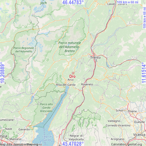
Dro GPS coordinates[2]
45° 57' 40.356" North, 10° 54' 43.236" East
| Map corner | latitude | longitude |
|---|---|---|
| Upper-left | 46.44783°, | 10.20889° |
| Center: | 45.96121°, | 10.91201° |
| Lower-right: | 45.47028°, | 11.61514° |
| Map W x H: | 108.7×108.7 km | = 67.5×67.5mi |
| max Lat: | 47.04031° ⇑9.1% North |
| Dro: | 45.96121° |
| min Lat: | ⇓90.9% South 35.50142° |
| min Long | Dro | max Long |
| 6.69888° | 10.91201° | 18.48682° |
| W 41.7%⇐ | ⇒58.3% E |
Elevation
Elevation of Dro is 123 m = 404 ft, and this is 183.7 m = 603 ft below average elevation for this country.
| Max E: |
2085 m = 6841 ft | 65.8% |
| Avg. | 306.7 m = 1006 ft | |
| Dro | 123 m = 404 ft | |
Min E: |
-4 m = -13 ft | 34.2% |
See also: Italy elevation on elevation.city.
Geographical zone
Dro is located in North temperate zone (between Tropic of Cancer and the Arctic Circle). Distance of this North polar circle is 2290.8 km =1423.4 mi to North.| Distance of | km | miles | from Dro |
|---|---|---|---|
| North Pole | 4896.7 | 3042.7 | to North |
| Arctic Circle | 2290.8 | 1423.4 | to North |
| Tropic Cancer | 2504.5 | 1556.2 | to South |
| Equator | 5110.4 | 3175.5 | to South |


Nearby cities:
15 places around Dro: (largest is in red/bold)
• Arco
5.2 km =3.2 mi,  202°
202°
• Bolognano-Vignole
5.5 km =3.4 mi,  185°
185°
• Castellano
8.4 km =5.2 mi,  119°
119°
• Cavedine
6.1 km =3.8 mi,  51°
51°
• Ceniga
1.4 km =0.9 mi,  216°
216°
• Cologna-Gavazzo Nuova
7.6 km =4.7 mi,  225°
225°
• Drena
2.7 km =1.7 mi,  70°
70°
• Fiavè
7.2 km =4.5 mi,  311°
311°
• Lasino
8.9 km =5.5 mi,  38°
38°
• Pietramurata
7 km =4.3 mi,  20°
20°
• Ponte Arche
8.8 km =5.5 mi,  339°
339°
• Ronzo-Chienis
8.5 km =5.3 mi,  159°
159°
• San Giorgio
7.6 km =4.7 mi,  209°
209°
• Tenno
7.8 km =4.8 mi, 233°
• Vigo
5.6 km =3.5 mi, 70°
Sources, notices
• [Note1] Compared only with cities in Italy existing in our database
• [Src1] Map data: © OpenStreetMap contributors (CC-BY-SA)
• [Src2] Other city data from geonames.org with taken over terms of usage.
• [Src3] Geographical zone / Annual Mean Temperature by Robert A. Rohde @ Wikipedia
