Cologna-Gavazzo Nuova geodata
Cologna-Gavazzo Nuova (Trentino-Alto Adige) is a section of populated place; located in Italy in Europe/Rome (GMT+2) time zone. With population of 713 people, there are 8204 cities with bigger population in this country. Compared to other cities in Italy, 89.6% of cities are located further ↓South; 59.3% of cities are located further →East and 54.7% of cities have higher elevation than Cologna-Gavazzo Nuova. Note1
Administrative division(s):
- Level 1: Trentino-Alto Adige
- Level 2: Provincia autonoma di Trento
- Level 3: Tenno
Current local time in Cologna-Gavazzo Nuova:
07:02 PM, WednesdayDifference from your time zone: hours


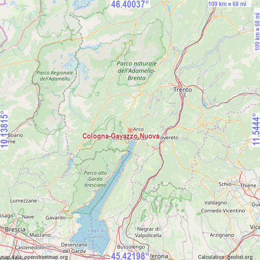
Cologna-Gavazzo Nuova GPS coordinates[2]
45° 54' 47.988" North, 10° 50' 28.572" East
| Map corner | latitude | longitude |
|---|---|---|
| Upper-left | 46.40037°, | 10.13815° |
| Center: | 45.91333°, | 10.84127° |
| Lower-right: | 45.42198°, | 11.5444° |
| Map W x H: | 108.8×108.8 km | = 67.6×67.6mi |
| max Lat: | 47.04031° ⇑10.4% North |
| Cologna-Gavazzo Nuova: | 45.91333° |
| min Lat: | ⇓89.6% South 35.50142° |
| min Long | Cologna-Gavazzo | max Long |
| 6.69888° | 10.84127° | 18.48682° |
| W 40.7%⇐ | ⇒59.3% E |
Elevation
Elevation of Cologna-Gavazzo Nuova is 204 m = 669 ft, and this is 102.7 m = 337 ft below average elevation for this country.
| Max E: |
2085 m = 6841 ft | 54.7% |
| Avg. | 306.7 m = 1006 ft | |
| Cologna-Gavazzo Nuova | 204 m = 669 ft | |
Min E: |
-4 m = -13 ft | 45.3% |
See also: Italy elevation on elevation.city.
Geographical zone
Cologna-Gavazzo Nuova is located in North temperate zone (between Tropic of Cancer and the Arctic Circle). Distance of this North polar circle is 2296.1 km =1426.7 mi to North.| Distance of | km | miles | from Cologna-Gavazzo Nuova |
|---|---|---|---|
| North Pole | 4902 | 3046 | to North |
| Arctic Circle | 2296.1 | 1426.7 | to North |
| Tropic Cancer | 2499.2 | 1552.9 | to South |
| Equator | 5105.1 | 3172.2 | to South |


Nearby cities:
15 places around Cologna-Gavazzo Nuova: (largest is in red/bold)
• Arco
3.5 km =2.2 mi,  82°
82°
• Bezzecca
9.7 km =6 mi,  259°
259°
• Bolognano-Vignole
4.9 km =3 mi,  91°
91°
• Ceniga
6.3 km =3.9 mi,  47°
47°
• Concei
8.7 km =5.4 mi, 264°
• Dro
7.6 km =4.7 mi, 45°
• Fiavè
10.1 km =6.3 mi,  0°
0°
• Molina di Ledro
7 km =4.3 mi,  227°
227°
• Nago-Torbole
5.7 km =3.5 mi,  137°
137°
• Pieve di Ledro
9 km =5.6 mi,  252°
252°
• Riva del Garda
3.1 km =1.9 mi,  180°
180°
• Ronzo-Chienis
8.8 km =5.5 mi,  107°
107°
• San Giorgio
2.1 km =1.3 mi,  126°
126°
• Tenno
1 km =0.6 mi,  311°
311°
• Torbole sul Garda
5.5 km =3.4 mi,  151°
151°
Sources, notices
• [Note1] Compared only with cities in Italy existing in our database
• [Src1] Map data: © OpenStreetMap contributors (CC-BY-SA)
• [Src2] Other city data from geonames.org with taken over terms of usage.
• [Src3] Geographical zone / Annual Mean Temperature by Robert A. Rohde @ Wikipedia
