Casa Rocco d'Amato geodata
Casa Rocco d'Amato (Campania) is a populated place; located in Italy in Europe/Rome (GMT+2) time zone. With population of 688 people, there are 8379 cities with bigger population in this country. Compared to other cities in Italy, 82.6% of cities are located further ↑North; 85.8% of cities are located further ←West and 54.9% of cities have higher elevation than Casa Rocco d'Amato. Note1


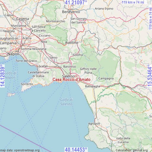
Casa Rocco d'Amato GPS coordinates[2]
40° 40' 47.568" North, 14° 49' 53.436" East
| Map corner | latitude | longitude |
|---|---|---|
| Upper-left | 41.21097°, | 14.12839° |
| Center: | 40.67988°, | 14.83151° |
| Lower-right: | 40.14453°, | 15.53464° |
| Map W x H: | 118.6×118.6 km | = 73.7×73.7mi |
| max Lat: | 47.04031° ⇑82.6% North |
| Casa Rocco d'Amato: | 40.67988° |
| min Lat: | ⇓17.4% South 35.50142° |
| min Long | Casa Rocco d'Am | max Long |
| 6.69888° | 14.83151° | 18.48682° |
| W 85.8%⇐ | ⇒14.2% E |
Elevation
Elevation of Casa Rocco d'Amato is 203 m = 666 ft, and this is 103.7 m = 340 ft below average elevation for this country.
| Max E: |
2085 m = 6841 ft | 54.9% |
| Avg. | 306.7 m = 1006 ft | |
| Casa Rocco d'Amato | 203 m = 666 ft | |
Min E: |
-4 m = -13 ft | 45.1% |
See also: Italy elevation on elevation.city.
Geographical zone
Casa Rocco d'Amato is located in North temperate zone (between Tropic of Cancer and the Arctic Circle). Distance of this Northern Tropic circle is 1917.3 km =1191.4 mi to South.| Distance of | km | miles | from Casa Rocco d'Amato |
|---|---|---|---|
| North Pole | 5483.9 | 3407.5 | to North |
| Arctic Circle | 2878 | 1788.3 | to North |
| Tropic Cancer | 1917.3 | 1191.4 | to South |
| Equator | 4523.2 | 2810.6 | to South |


Nearby cities:
15 places around Casa Rocco d'Amato: (largest is in red/bold)
• Campigliano
3.5 km =2.2 mi,  85°
85°
• Capezzano Inferiore
5.4 km =3.4 mi,  295°
295°
• Capezzano-Cologna
6.3 km =3.9 mi,  308°
308°
• Castiglione del Genovesi
5.1 km =3.2 mi,  15°
15°
• Coperchia
7.1 km =4.4 mi, 309°
• Faiano
6.3 km =3.9 mi,  107°
107°
• Fuorni
4.6 km =2.9 mi,  161°
161°
• Malche-Santa Croce-Serroni
7.1 km =4.4 mi,  62°
62°
• Pezzano-Filetta
3.8 km =2.4 mi, 58°
• Piegolelle-San Bartolomeo
1 km =0.6 mi, 313°
• Pontecagnano
5.5 km =3.4 mi,  136°
136°
• Prepezzano
7.3 km =4.5 mi,  43°
43°
• Salerno
3.3 km =2.1 mi,  261°
261°
• San Cipriano Picentino
5.6 km =3.5 mi, 37°
• San Mango Piemonte
2.4 km =1.5 mi, 15°
Sources, notices
• [Note1] Compared only with cities in Italy existing in our database
• [Src1] Map data: © OpenStreetMap contributors (CC-BY-SA)
• [Src2] Other city data from geonames.org with taken over terms of usage.
• [Src3] Geographical zone / Annual Mean Temperature by Robert A. Rohde @ Wikipedia
