Sant'Arcangelo geodata
Sant'Arcangelo (Basilicate) is a seat of a third-order administrative division; located in Italy in Europe/Rome (GMT+2) time zone. With population of 2,432 people, there are 3607 cities with bigger population in this country. Compared to other cities in Italy, 86.1% of cities are located further ↑North; 94.9% of cities are located further ←West and 64.5% of cities have lower elevation than Sant'Arcangelo. Note1
Administrative division(s):
- Level 1: Basilicate
- Level 2: Provincia di Potenza
- Level 3: Sant'Arcangelo


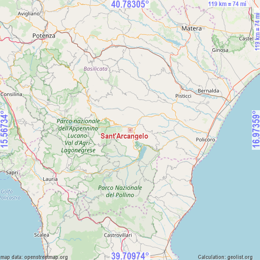
Sant'Arcangelo GPS coordinates[2]
40° 14' 54.672" North, 16° 16' 13.656" East
| Map corner | latitude | longitude |
|---|---|---|
| Upper-left | 40.78305°, | 15.56734° |
| Center: | 40.24852°, | 16.27046° |
| Lower-right: | 39.70974°, | 16.97359° |
| Map W x H: | 119.3×119.3 km | = 74.1×74.1mi |
| max Lat: | 47.04031° ⇑86.1% North |
| Sant'Arcangelo: | 40.24852° |
| min Lat: | ⇓13.9% South 35.50142° |
| min Long | Sant'Arcangelo | max Long |
| 6.69888° | 16.27046° | 18.48682° |
| W 94.9%⇐ | ⇒5.1% E |
Elevation
Elevation of Sant'Arcangelo is 338 m = 1109 ft, and this is 31.3 m = 103 ft above average elevation for this country.
| Max E: |
2085 m = 6841 ft | 35.5% |
| Sant'Arcangelo | 338 m 1109 ft | |
| Avg. | 306.7 m = 1006 ft | |
Min E: |
-4 m = -13 ft | 64.5% |
See also: Italy elevation on elevation.city.
Geographical zone
Sant'Arcangelo is located in North temperate zone (between Tropic of Cancer and the Arctic Circle). Distance of this Northern Tropic circle is 1869.3 km =1161.5 mi to South.| Distance of | km | miles | from Sant'Arcangelo |
|---|---|---|---|
| North Pole | 5531.8 | 3437.3 | to North |
| Arctic Circle | 2926 | 1818.1 | to North |
| Tropic Cancer | 1869.3 | 1161.5 | to South |
| Equator | 4475.2 | 2780.8 | to South |


Nearby cities:
15 places around Sant'Arcangelo: (largest is in red/bold)
• Aliano
8 km =5 mi,  334°
334°
• Calvera
15.5 km =9.6 mi,  224°
224°
• Castronuovo di Sant'Andrea
9.8 km =6.1 mi,  227°
227°
• Chiaromonte
14.7 km =9.1 mi,  198°
198°
• Colobraro
14.7 km =9.1 mi,  117°
117°
• Fardella
17.2 km =10.7 mi,  209°
209°
• Gallicchio
12.4 km =7.7 mi,  293°
293°
• Missanello
9.6 km =6 mi, 293°
• Roccanova
6.9 km =4.3 mi, 234°
• San Brancato
1.6 km =1 mi,  312°
312°
• Senise
11.5 km =7.1 mi,  172°
172°
• Stigliano
17.4 km =10.8 mi,  348°
348°
• Teana
16.9 km =10.5 mi, 216°
• Tursi
17.1 km =10.6 mi,  90°
90°
• Valsinni
17.1 km =10.6 mi, 120°
Sources, notices
• [Note1] Compared only with cities in Italy existing in our database
• [Src1] Map data: © OpenStreetMap contributors (CC-BY-SA)
• [Src2] Other city data from geonames.org with taken over terms of usage.
• [Src3] Geographical zone / Annual Mean Temperature by Robert A. Rohde @ Wikipedia
