Cervara geodata
Cervara (Emilia-Romagna) is a populated place; located in Italy in Europe/Rome (GMT+2) time zone. With population of 580 people, there are 9180 cities with bigger population in this country. Compared to other cities in Italy, 57.3% of cities are located further ↓South; 65% of cities are located further →East and 83.4% of cities have higher elevation than Cervara. Note1


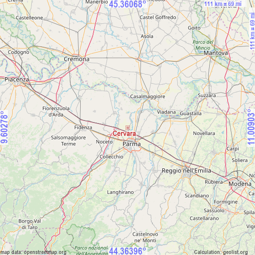
Cervara GPS coordinates[2]
44° 51' 52.128" North, 10° 18' 21.24" East
| Map corner | latitude | longitude |
|---|---|---|
| Upper-left | 45.36068°, | 9.60278° |
| Center: | 44.86448°, | 10.3059° |
| Lower-right: | 44.36396°, | 11.00903° |
| Map W x H: | 110.8×110.8 km | = 68.8×68.8mi |
| max Lat: | 47.04031° ⇑42.7% North |
| Cervara: | 44.86448° |
| min Lat: | ⇓57.3% South 35.50142° |
| min Long | Cervara | max Long |
| 6.69888° | 10.3059° | 18.48682° |
| W 35%⇐ | ⇒65% E |
Elevation
Elevation of Cervara is 36 m = 118 ft, and this is 270.7 m = 888 ft below average elevation for this country.
| Max E: |
2085 m = 6841 ft | 83.4% |
| Avg. | 306.7 m = 1006 ft | |
| Cervara | 36 m = 118 ft | |
Min E: |
-4 m = -13 ft | 16.6% |
See also: Italy elevation on elevation.city.
Geographical zone
Cervara is located in North temperate zone (between Tropic of Cancer and the Arctic Circle). Distance of this Northern Tropic circle is 2382.5 km =1480.4 mi to South.| Distance of | km | miles | from Cervara |
|---|---|---|---|
| North Pole | 5018.6 | 3118.4 | to North |
| Arctic Circle | 2412.7 | 1499.2 | to North |
| Tropic Cancer | 2382.5 | 1480.4 | to South |
| Equator | 4988.5 | 3099.7 | to South |


Nearby cities:
15 places around Cervara: (largest is in red/bold)
• Baganzola
1 km =0.6 mi,  174°
174°
• Colorno
8.6 km =5.3 mi,  38°
38°
• Eia
4.6 km =2.9 mi,  223°
223°
• Fontanellato
10.4 km =6.5 mi,  280°
280°
• Fontevivo
10.5 km =6.5 mi,  266°
266°
• Madregolo
10.5 km =6.5 mi, 219°
• Parma
7.4 km =4.6 mi, 167°
• Ponte Taro
8.5 km =5.3 mi,  242°
242°
• Rivarolo
4.5 km =2.8 mi,  10°
10°
• Ronco Campo Canneto
5.8 km =3.6 mi,  321°
321°
• San Polo
4.9 km =3 mi,  55°
55°
• San Secondo Parmense
8.7 km =5.4 mi, 317°
• Torrile
6.9 km =4.3 mi, 11°
• Trecasali
8.5 km =5.3 mi,  342°
342°
• Vicofertile
9.4 km =5.8 mi,  201°
201°
Sources, notices
• [Note1] Compared only with cities in Italy existing in our database
• [Src1] Map data: © OpenStreetMap contributors (CC-BY-SA)
• [Src2] Other city data from geonames.org with taken over terms of usage.
• [Src3] Geographical zone / Annual Mean Temperature by Robert A. Rohde @ Wikipedia
