Rivarolo geodata
Rivarolo (Emilia-Romagna) is a populated place; located in Italy in Europe/Rome (GMT+2) time zone. With population of 882 people, there are 7255 cities with bigger population in this country. Compared to other cities in Italy, 58% of cities are located further ↓South; 64.9% of cities are located further →East and 83.4% of cities have higher elevation than Rivarolo. Note1


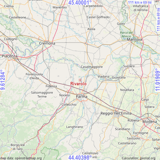
Rivarolo GPS coordinates[2]
44° 54' 14.94" North, 10° 18' 57.456" East
| Map corner | latitude | longitude |
|---|---|---|
| Upper-left | 45.40001°, | 9.61284° |
| Center: | 44.90415°, | 10.31596° |
| Lower-right: | 44.40398°, | 11.01909° |
| Map W x H: | 110.7×110.7 km | = 68.8×68.8mi |
| max Lat: | 47.04031° ⇑42% North |
| Rivarolo: | 44.90415° |
| min Lat: | ⇓58% South 35.50142° |
| min Long | Rivarolo | max Long |
| 6.69888° | 10.31596° | 18.48682° |
| W 35.1%⇐ | ⇒64.9% E |
Elevation
Elevation of Rivarolo is 36 m = 118 ft, and this is 270.7 m = 888 ft below average elevation for this country.
| Max E: |
2085 m = 6841 ft | 83.4% |
| Avg. | 306.7 m = 1006 ft | |
| Rivarolo | 36 m = 118 ft | |
Min E: |
-4 m = -13 ft | 16.6% |
See also: Italy elevation on elevation.city.
Geographical zone
Rivarolo is located in North temperate zone (between Tropic of Cancer and the Arctic Circle). Distance of this Northern Tropic circle is 2387 km =1483.2 mi to South.| Distance of | km | miles | from Rivarolo |
|---|---|---|---|
| North Pole | 5014.2 | 3115.7 | to North |
| Arctic Circle | 2408.3 | 1496.4 | to North |
| Tropic Cancer | 2387 | 1483.2 | to South |
| Equator | 4992.9 | 3102.4 | to South |


Nearby cities:
15 places around Rivarolo: (largest is in red/bold)
• Baganzola
5.5 km =3.4 mi,  187°
187°
• Casale
9.2 km =5.7 mi,  81°
81°
• Casale di Mezzani
9.1 km =5.7 mi, 82°
• Cervara
4.5 km =2.8 mi, 190°
• Colorno
5.1 km =3.2 mi,  62°
62°
• Coltaro
6.9 km =4.3 mi,  2°
2°
• Eia
8.7 km =5.4 mi,  207°
207°
• Fontanelle
10.8 km =6.7 mi,  312°
312°
• Mezzano Superiore
9.1 km =5.7 mi,  69°
69°
• Ronco Campo Canneto
4.4 km =2.7 mi,  271°
271°
• San Polo
3.6 km =2.2 mi,  116°
116°
• San Secondo Parmense
7 km =4.3 mi,  286°
286°
• Sissa
7.5 km =4.7 mi,  324°
324°
• Torrile
2.4 km =1.5 mi,  14°
14°
• Trecasali
5 km =3.1 mi, 317°
Sources, notices
• [Note1] Compared only with cities in Italy existing in our database
• [Src1] Map data: © OpenStreetMap contributors (CC-BY-SA)
• [Src2] Other city data from geonames.org with taken over terms of usage.
• [Src3] Geographical zone / Annual Mean Temperature by Robert A. Rohde @ Wikipedia
