Trecasali geodata
Trecasali (Emilia-Romagna) is a seat of a third-order administrative division; located in Italy in Europe/Rome (GMT+2) time zone. With population of 1,917 people, there are 4292 cities with bigger population in this country. Compared to other cities in Italy, 58.6% of cities are located further ↓South; 65.3% of cities are located further →East and 84.4% of cities have higher elevation than Trecasali. Note1
Administrative division(s):
- Level 1: Emilia-Romagna
- Level 2: Provincia di Parma
- Level 3: Sissa Trecasali


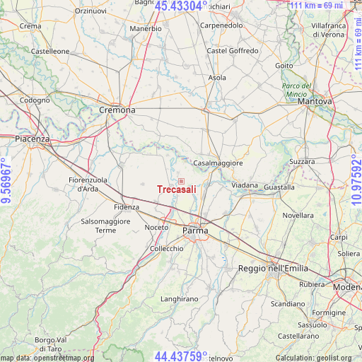
Trecasali GPS coordinates[2]
44° 56' 14.892" North, 10° 16' 22.044" East
| Map corner | latitude | longitude |
|---|---|---|
| Upper-left | 45.43304°, | 9.56967° |
| Center: | 44.93747°, | 10.27279° |
| Lower-right: | 44.43759°, | 10.97592° |
| Map W x H: | 110.7×110.7 km | = 68.8×68.8mi |
| max Lat: | 47.04031° ⇑41.4% North |
| Trecasali: | 44.93747° |
| min Lat: | ⇓58.6% South 35.50142° |
| min Long | Trecasali | max Long |
| 6.69888° | 10.27279° | 18.48682° |
| W 34.7%⇐ | ⇒65.3% E |
Elevation
Elevation of Trecasali is 33 m = 108 ft, and this is 273.7 m = 898 ft below average elevation for this country.
| Max E: |
2085 m = 6841 ft | 84.4% |
| Avg. | 306.7 m = 1006 ft | |
| Trecasali | 33 m = 108 ft | |
Min E: |
-4 m = -13 ft | 15.6% |
See also: Italy elevation on elevation.city.
Geographical zone
Trecasali is located in North temperate zone (between Tropic of Cancer and the Arctic Circle). Distance of this Northern Tropic circle is 2390.7 km =1485.5 mi to South.| Distance of | km | miles | from Trecasali |
|---|---|---|---|
| North Pole | 5010.5 | 3113.4 | to North |
| Arctic Circle | 2404.6 | 1494.1 | to North |
| Tropic Cancer | 2390.7 | 1485.5 | to South |
| Equator | 4996.6 | 3104.7 | to South |


Nearby cities:
15 places around Trecasali: (largest is in red/bold)
• Baganzola
9.5 km =5.9 mi,  163°
163°
• Cervara
8.5 km =5.3 mi, 162°
• Colorno
8 km =5 mi,  99°
99°
• Coltaro
4.9 km =3 mi,  49°
49°
• Fontanellato
9.8 km =6.1 mi,  230°
230°
• Fontanelle
5.8 km =3.6 mi,  308°
308°
• Gussola
10.2 km =6.3 mi,  35°
35°
• Rivarolo
5 km =3.1 mi,  137°
137°
• Roccabianca
8.9 km =5.5 mi,  331°
331°
• Ronco Campo Canneto
3.7 km =2.3 mi,  196°
196°
• San Polo
8.5 km =5.3 mi,  128°
128°
• San Secondo Parmense
3.7 km =2.3 mi,  243°
243°
• Sissa
2.6 km =1.6 mi,  338°
338°
• Torricella del Pizzo
9.4 km =5.8 mi,  10°
10°
• Torrile
4.2 km =2.6 mi,  108°
108°
Sources, notices
• [Note1] Compared only with cities in Italy existing in our database
• [Src1] Map data: © OpenStreetMap contributors (CC-BY-SA)
• [Src2] Other city data from geonames.org with taken over terms of usage.
• [Src3] Geographical zone / Annual Mean Temperature by Robert A. Rohde @ Wikipedia
