Port Antonio geodata
Port Antonio (Portland) is a seat of a first-order administrative division; located in Jamaica in America/Jamaica (GMT-5) time zone. With population of 14,400 people, there are 11 cities with bigger population in this country. Compared to other cities in Jamaica, 57.1% of cities are located further ↓South; 93.4% of cities are located further ←West and 86.8% of cities have higher elevation than Port Antonio. Note1


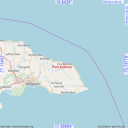
Port Antonio GPS coordinates[2]
18° 10' 34.14" North, 76° 27' 3.24" West
| Map corner | latitude | longitude |
|---|---|---|
| Upper-left | 18.8429°, | -77.15403° |
| Center: | 18.17615°, | -76.4509° |
| Lower-right: | 17.50684°, | -75.74778° |
| Map W x H: | 148.6×148.6 km | = 92.3×92.3mi |
| max Lat: | 18.49358° ⇑42.9% North |
| Port Antonio: | 18.17615° |
| min Lat: | ⇓57.1% South 17.774° |
| min Long | Port Antonio | max Long |
| -78.3481° | -76.4509° | -76.24864° |
| W 93.4%⇐ | ⇒6.6% E |
Elevation
Elevation of Port Antonio is 13 m = 43 ft, and this is 201.4 m = 661 ft below average elevation for this country.
| Max E: |
944 m = 3097 ft | 86.8% |
| Avg. | 214.4 m = 703 ft | |
| Port Antonio | 13 m = 43 ft | |
Min E: |
1 m = 3 ft | 13.2% |
See also: Jamaica elevation on elevation.city.
Geographical zone
Port Antonio is located in North Torrid zone (between Equator and Tropic of Cancer). Distance of this Northern Tropic circle is 584.9 km =363.4 mi to North.| Distance of | km | miles | from Port Antonio |
|---|---|---|---|
| North Pole | 7986.1 | 4962.3 | to North |
| Arctic Circle | 5380.2 | 3343.1 | to North |
| Tropic Cancer | 584.9 | 363.4 | to North |
| Equator | 2021 | 1255.8 | to South |


Nearby cities:
15 places around Port Antonio: (largest is in red/bold)
• Annotto Bay
34.9 km =21.7 mi,  287°
287°
• Bath
27.5 km =17.1 mi,  157°
157°
• Buff Bay
23.1 km =14.4 mi, 285°
• Dalvey
36.3 km =22.6 mi,  143°
143°
• Easington
31.6 km =19.6 mi,  207°
207°
• Golden Grove
32.9 km =20.4 mi,  145°
145°
• Gordon Town
32.2 km =20 mi,  241°
241°
• Hope Bay
12.4 km =7.7 mi,  281°
281°
• Manchioneal
23.5 km =14.6 mi,  128°
128°
• Mavis Bank
27.8 km =17.3 mi, 235°
• Moore Town
11.3 km =7 mi,  166°
166°
• Morant Bay
33.1 km =20.6 mi, 172°
• Seaforth
26.7 km =16.6 mi,  181°
181°
• Trinity Ville
24.9 km =15.5 mi,  195°
195°
• Yallahs
35.5 km =22.1 mi, 199°
Sources, notices
• [Note1] Compared only with cities in Jamaica existing in our database
• [Src1] Map data: © OpenStreetMap contributors (CC-BY-SA)
• [Src2] Other city data from geonames.org with taken over terms of usage.
• [Src3] Geographical zone / Annual Mean Temperature by Robert A. Rohde @ Wikipedia
