Dalvey geodata
Dalvey (St. Thomas) is a populated place; located in Jamaica in America/Jamaica (GMT-5) time zone. With population of 3,037 people, there are 54 cities with bigger population in this country. Compared to other cities in Jamaica, 89% of cities are located further ↑North; 100% of cities are located further ←West and 65.9% of cities have higher elevation than Dalvey. Note1


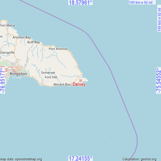
Dalvey GPS coordinates[2]
17° 54' 42.624" North, 76° 14' 55.104" West
| Map corner | latitude | longitude |
|---|---|---|
| Upper-left | 18.57961°, | -76.95177° |
| Center: | 17.91184°, | -76.24864° |
| Lower-right: | 17.24155°, | -75.54552° |
| Map W x H: | 148.8×148.8 km | = 92.5×92.5mi |
| max Lat: | 18.49358° ⇑89% North |
| Dalvey: | 17.91184° |
| min Lat: | ⇓11% South 17.774° |
| min Long | Dalvey | max Long |
| -78.3481° | -76.24864° | -76.24864° |
| W 100%⇐ | ⇒0% E |
Elevation
Elevation of Dalvey is 49 m = 161 ft, and this is 165.4 m = 543 ft below average elevation for this country.
| Max E: |
944 m = 3097 ft | 65.9% |
| Avg. | 214.4 m = 703 ft | |
| Dalvey | 49 m = 161 ft | |
Min E: |
1 m = 3 ft | 34.1% |
See also: Jamaica elevation on elevation.city.
Geographical zone
Dalvey is located in North Torrid zone (between Equator and Tropic of Cancer). Distance of this Northern Tropic circle is 614.3 km =381.7 mi to North.| Distance of | km | miles | from Dalvey |
|---|---|---|---|
| North Pole | 8015.5 | 4980.6 | to North |
| Arctic Circle | 5409.6 | 3361.4 | to North |
| Tropic Cancer | 614.3 | 381.7 | to North |
| Equator | 1991.6 | 1237.5 | to South |


Nearby cities:
15 places around Dalvey: (largest is in red/bold)
• Bath
11.4 km =7.1 mi,  290°
290°
• Buff Bay
56.4 km =35 mi,  309°
309°
• Easington
36 km =22.4 mi,  272°
272°
• Golden Grove
3.5 km =2.2 mi, 313°
• Gordon Town
51.5 km =32 mi, 285°
• Hope Bay
46.3 km =28.8 mi, 313°
• Manchioneal
15.1 km =9.4 mi,  348°
348°
• Mavis Bank
46.2 km =28.7 mi, 286°
• Mona Heights
54.4 km =33.8 mi,  282°
282°
• Moore Town
26.3 km =16.3 mi, 314°
• Morant Bay
17.3 km =10.7 mi,  258°
258°
• Port Antonio
36.3 km =22.6 mi,  323°
323°
• Seaforth
22.2 km =13.8 mi, 276°
• Trinity Ville
28.6 km =17.8 mi, 280°
• Yallahs
33.5 km =20.8 mi, 262°
Sources, notices
• [Note1] Compared only with cities in Jamaica existing in our database
• [Src1] Map data: © OpenStreetMap contributors (CC-BY-SA)
• [Src2] Other city data from geonames.org with taken over terms of usage.
• [Src3] Geographical zone / Annual Mean Temperature by Robert A. Rohde @ Wikipedia
