Morant Bay geodata
Morant Bay (St. Thomas) is a seat of a first-order administrative division; located in Jamaica in America/Jamaica (GMT-5) time zone. With population of 9,368 people, there are 18 cities with bigger population in this country. Compared to other cities in Jamaica, 93.4% of cities are located further ↑North; 95.6% of cities are located further ←West and 76.9% of cities have higher elevation than Morant Bay. Note1


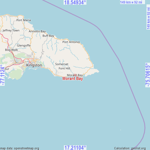
Morant Bay GPS coordinates[2]
17° 52' 53.22" North, 76° 24' 33.372" West
| Map corner | latitude | longitude |
|---|---|---|
| Upper-left | 18.54934°, | -77.1124° |
| Center: | 17.88145°, | -76.40927° |
| Lower-right: | 17.21104°, | -75.70615° |
| Map W x H: | 148.8×148.8 km | = 92.5×92.5mi |
| max Lat: | 18.49358° ⇑93.4% North |
| Morant Bay: | 17.88145° |
| min Lat: | ⇓6.6% South 17.774° |
| min Long | Morant Bay | max Long |
| -78.3481° | -76.40927° | -76.24864° |
| W 95.6%⇐ | ⇒4.4% E |
Elevation
Elevation of Morant Bay is 22 m = 72 ft, and this is 192.4 m = 631 ft below average elevation for this country.
| Max E: |
944 m = 3097 ft | 76.9% |
| Avg. | 214.4 m = 703 ft | |
| Morant Bay | 22 m = 72 ft | |
Min E: |
1 m = 3 ft | 23.1% |
See also: Jamaica elevation on elevation.city.
Geographical zone
Morant Bay is located in North Torrid zone (between Equator and Tropic of Cancer). Distance of this Northern Tropic circle is 617.7 km =383.8 mi to North.| Distance of | km | miles | from Morant Bay |
|---|---|---|---|
| North Pole | 8018.8 | 4982.6 | to North |
| Arctic Circle | 5412.9 | 3363.4 | to North |
| Tropic Cancer | 617.7 | 383.8 | to North |
| Equator | 1988.2 | 1235.4 | to South |


Nearby cities:
15 places around Morant Bay: (largest is in red/bold)
• Bath
9.8 km =6.1 mi,  40°
40°
• Dalvey
17.3 km =10.7 mi,  78°
78°
• Easington
19.5 km =12.1 mi,  284°
284°
• Golden Grove
15.6 km =9.7 mi,  68°
68°
• Gordon Town
36.9 km =22.9 mi,  297°
297°
• Hope Bay
39 km =24.2 mi,  334°
334°
• Manchioneal
22.9 km =14.2 mi, 37°
• Mavis Bank
32 km =19.9 mi, 301°
• Mona Heights
39.1 km =24.3 mi,  292°
292°
• Moore Town
21.9 km =13.6 mi,  355°
355°
• New Kingston
42 km =26.1 mi, 289°
• Port Antonio
33.1 km =20.6 mi,  352°
352°
• Seaforth
7.9 km =4.9 mi,  319°
319°
• Trinity Ville
14.2 km =8.8 mi,  308°
308°
• Yallahs
16.2 km =10.1 mi,  267°
267°
Sources, notices
• [Note1] Compared only with cities in Jamaica existing in our database
• [Src1] Map data: © OpenStreetMap contributors (CC-BY-SA)
• [Src2] Other city data from geonames.org with taken over terms of usage.
• [Src3] Geographical zone / Annual Mean Temperature by Robert A. Rohde @ Wikipedia
