Buff Bay geodata
Buff Bay (Portland) is a populated place; located in Jamaica in America/Jamaica (GMT-5) time zone. With population of 2,757 people, there are 63 cities with bigger population in this country. Compared to other cities in Jamaica, 62.6% of cities are located further ↓South; 86.8% of cities are located further ←West and 81.3% of cities have higher elevation than Buff Bay. Note1


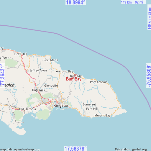
Buff Bay GPS coordinates[2]
18° 13' 58.332" North, 76° 39' 40.248" West
| Map corner | latitude | longitude |
|---|---|---|
| Upper-left | 18.8994°, | -77.36431° |
| Center: | 18.23287°, | -76.66118° |
| Lower-right: | 17.56378°, | -75.95806° |
| Map W x H: | 148.5×148.5 km | = 92.3×92.3mi |
| max Lat: | 18.49358° ⇑37.4% North |
| Buff Bay: | 18.23287° |
| min Lat: | ⇓62.6% South 17.774° |
| min Long | Buff Bay | max Long |
| -78.3481° | -76.66118° | -76.24864° |
| W 86.8%⇐ | ⇒13.2% E |
Elevation
Elevation of Buff Bay is 15 m = 49 ft, and this is 199.4 m = 654 ft below average elevation for this country.
| Max E: |
944 m = 3097 ft | 81.3% |
| Avg. | 214.4 m = 703 ft | |
| Buff Bay | 15 m = 49 ft | |
Min E: |
1 m = 3 ft | 18.7% |
See also: Jamaica elevation on elevation.city.
Geographical zone
Buff Bay is located in North Torrid zone (between Equator and Tropic of Cancer). Distance of this Northern Tropic circle is 578.6 km =359.5 mi to North.| Distance of | km | miles | from Buff Bay |
|---|---|---|---|
| North Pole | 7979.8 | 4958.4 | to North |
| Arctic Circle | 5373.9 | 3339.2 | to North |
| Tropic Cancer | 578.6 | 359.5 | to North |
| Equator | 2027.3 | 1259.7 | to South |


Nearby cities:
15 places around Buff Bay: (largest is in red/bold)
• Annotto Bay
11.8 km =7.3 mi,  291°
291°
• Constant Spring
24.6 km =15.3 mi,  214°
214°
• Gordon Town
22.7 km =14.1 mi,  195°
195°
• Half Way Tree
28.5 km =17.7 mi, 210°
• Hope Bay
10.8 km =6.7 mi,  110°
110°
• Islington
22.1 km =13.7 mi, 292°
• Kingston
29.7 km =18.5 mi, 208°
• Mavis Bank
22.2 km =13.8 mi,  181°
181°
• Mona Heights
26.2 km =16.3 mi, 201°
• Moore Town
30.3 km =18.8 mi,  124°
124°
• New Kingston
28.2 km =17.5 mi, 207°
• Port Antonio
23.1 km =14.4 mi, 105°
• Port Maria
28.4 km =17.6 mi,  302°
302°
• Richmond
24.1 km =15 mi,  275°
275°
• Stony Hill
21.5 km =13.4 mi,  217°
217°
Sources, notices
• [Note1] Compared only with cities in Jamaica existing in our database
• [Src1] Map data: © OpenStreetMap contributors (CC-BY-SA)
• [Src2] Other city data from geonames.org with taken over terms of usage.
• [Src3] Geographical zone / Annual Mean Temperature by Robert A. Rohde @ Wikipedia
