Mona Heights geodata
Mona Heights (St. Andrew) is a section of populated place; located in Jamaica in America/Jamaica (GMT-5) time zone. With population of 2,887 people, there are 59 cities with bigger population in this country. Compared to other cities in Jamaica, 71.4% of cities are located further ↑North; 83.5% of cities are located further ←West and 60.4% of cities have lower elevation than Mona Heights. Note1


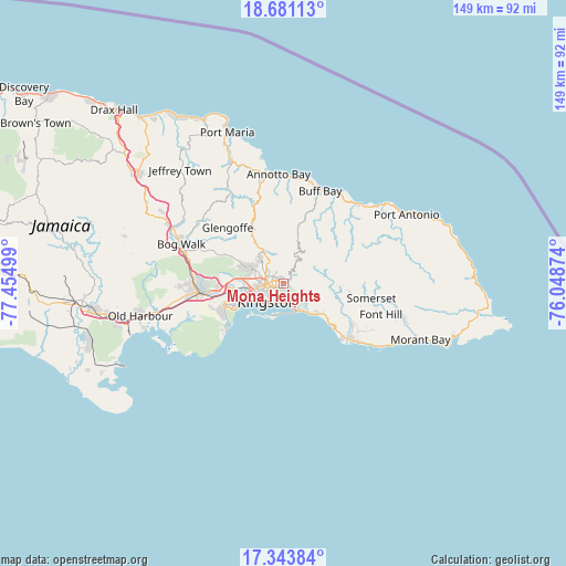
Mona Heights GPS coordinates[2]
18° 0' 49.5" North, 76° 45' 6.696" West
| Map corner | latitude | longitude |
|---|---|---|
| Upper-left | 18.68113°, | -77.45499° |
| Center: | 18.01375°, | -76.75186° |
| Lower-right: | 17.34384°, | -76.04874° |
| Map W x H: | 148.7×148.7 km | = 92.4×92.4mi |
| max Lat: | 18.49358° ⇑71.4% North |
| Mona Heights: | 18.01375° |
| min Lat: | ⇓28.6% South 17.774° |
| min Long | Mona Heights | max Long |
| -78.3481° | -76.75186° | -76.24864° |
| W 83.5%⇐ | ⇒16.5% E |
Elevation
Elevation of Mona Heights is 191 m = 627 ft, and this is 23.4 m = 77 ft below average elevation for this country.
| Max E: |
944 m = 3097 ft | 39.6% |
| Avg. | 214.4 m = 703 ft | |
| Mona Heights | 191 m = 627 ft | |
Min E: |
1 m = 3 ft | 60.4% |
See also: Jamaica elevation on elevation.city.
Geographical zone
Mona Heights is located in North Torrid zone (between Equator and Tropic of Cancer). Distance of this Northern Tropic circle is 603 km =374.7 mi to North.| Distance of | km | miles | from Mona Heights |
|---|---|---|---|
| North Pole | 8004.1 | 4973.5 | to North |
| Arctic Circle | 5398.2 | 3354.3 | to North |
| Tropic Cancer | 603 | 374.7 | to North |
| Equator | 2002.9 | 1244.5 | to South |


Nearby cities:
15 places around Mona Heights: (largest is in red/bold)
• Buff Bay
26.2 km =16.3 mi,  21°
21°
• Constant Spring
6 km =3.7 mi,  312°
312°
• Easington
20 km =12.4 mi,  119°
119°
• Gordon Town
4.4 km =2.7 mi,  55°
55°
• Half Way Tree
5 km =3.1 mi,  268°
268°
• Kingston
4.8 km =3 mi,  247°
247°
• Mavis Bank
9.3 km =5.8 mi,  76°
76°
• New Kingston
3.4 km =2.1 mi,  258°
258°
• Port Royal
12.7 km =7.9 mi,  227°
227°
• Portmore
15.5 km =9.6 mi,  242°
242°
• Riversdale
28.1 km =17.5 mi, 307°
• Spanish Town
21.9 km =13.6 mi, 263°
• Stony Hill
8.1 km =5 mi,  334°
334°
• Trinity Ville
25.8 km =16 mi,  103°
103°
• Yallahs
25.3 km =15.7 mi,  127°
127°
Sources, notices
• [Note1] Compared only with cities in Jamaica existing in our database
• [Src1] Map data: © OpenStreetMap contributors (CC-BY-SA)
• [Src2] Other city data from geonames.org with taken over terms of usage.
• [Src3] Geographical zone / Annual Mean Temperature by Robert A. Rohde @ Wikipedia
