New Kingston geodata
New Kingston (St. Andrew) is a section of populated place; located in Jamaica in America/Jamaica (GMT-5) time zone. With population of 583,958 people, there is 1 city with bigger population in this country. Compared to other cities in Jamaica, 73.6% of cities are located further ↑North; 81.3% of cities are located further ←West and 52.7% of cities have higher elevation than New Kingston. Note1


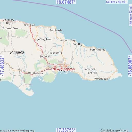
New Kingston GPS coordinates[2]
18° 0' 26.892" North, 76° 46' 59.484" West
| Map corner | latitude | longitude |
|---|---|---|
| Upper-left | 18.67487°, | -77.48632° |
| Center: | 18.00747°, | -76.78319° |
| Lower-right: | 17.33753°, | -76.08007° |
| Map W x H: | 148.7×148.7 km | = 92.4×92.4mi |
| max Lat: | 18.49358° ⇑73.6% North |
| New Kingston: | 18.00747° |
| min Lat: | ⇓26.4% South 17.774° |
| min Long | New Kingston | max Long |
| -78.3481° | -76.78319° | -76.24864° |
| W 81.3%⇐ | ⇒18.7% E |
Elevation
Elevation of New Kingston is 99 m = 325 ft, and this is 115.4 m = 379 ft below average elevation for this country.
| Max E: |
944 m = 3097 ft | 52.7% |
| Avg. | 214.4 m = 703 ft | |
| New Kingston | 99 m = 325 ft | |
Min E: |
1 m = 3 ft | 47.3% |
See also: New Kingston elevation on elevation.city.
Geographical zone
New Kingston is located in North Torrid zone (between Equator and Tropic of Cancer). Distance of this Northern Tropic circle is 603.7 km =375.1 mi to North.| Distance of | km | miles | from New Kingston |
|---|---|---|---|
| North Pole | 8004.8 | 4974 | to North |
| Arctic Circle | 5398.9 | 3354.7 | to North |
| Tropic Cancer | 603.7 | 375.1 | to North |
| Equator | 2002.2 | 1244.1 | to South |


Nearby cities:
15 places around New Kingston: (largest is in red/bold)
• Bog Walk
25.7 km =16 mi,  294°
294°
• Buff Bay
28.2 km =17.5 mi,  27°
27°
• Constant Spring
4.9 km =3 mi,  346°
346°
• Easington
22.6 km =14 mi,  114°
114°
• Gordon Town
7.6 km =4.7 mi,  65°
65°
• Half Way Tree
1.8 km =1.1 mi, 288°
• Kingston
1.6 km =1 mi,  223°
223°
• Mavis Bank
12.7 km =7.9 mi,  76°
76°
• Mona Heights
3.4 km =2.1 mi, 78°
• Port Royal
9.9 km =6.2 mi, 217°
• Portmore
12.2 km =7.6 mi,  238°
238°
• Riversdale
26 km =16.2 mi,  312°
312°
• Spanish Town
18.5 km =11.5 mi,  264°
264°
• Stony Hill
8 km =5 mi,  358°
358°
• Yallahs
27.6 km =17.1 mi,  122°
122°
Sources, notices
• [Note1] Compared only with cities in Jamaica existing in our database
• [Src1] Map data: © OpenStreetMap contributors (CC-BY-SA)
• [Src2] Other city data from geonames.org with taken over terms of usage.
• [Src3] Geographical zone / Annual Mean Temperature by Robert A. Rohde @ Wikipedia
